Home > North America > United States of America > Oregon > Portland
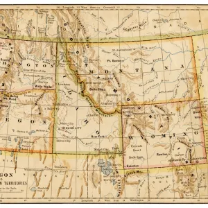
Portland Oregon US City Street Map

![]()
Wall Art and Photo Gifts from Fine Art Storehouse
Portland Oregon US City Street Map
Vector Illustration of a City Street Map of Portland, Oregon, USA. Scale 1:60, 000.
All source data is in the public domain.
U.S. Geological Survey, US Topo
Used Layers:
USGS The National Map: National Hydrography Dataset (NHD)
USGS The National Map: National Transportation Dataset (NTD)
Unleash your creativity and transform your space into a visual masterpiece!
Frank Ramspott
Media ID 15054909
© Frank Ramspott, all rights reserved
Aerial View City Map Computer Graphic Directly Above Downtown District Gray Oregon Portland Road Map Text Willamette River Digitally Generated Image White Color
FEATURES IN THESE COLLECTIONS
> Aerial Photography
> Related Images
> Arts
> Landscape paintings
> Waterfall and river artworks
> River artworks
> Arts
> Portraits
> Pop art gallery
> Street art portraits
> Fine Art Storehouse
> Map
> Street Maps
> Fine Art Storehouse
> Map
> USA Maps
> Maps and Charts
> Geological Map
> North America
> United States of America
> Lakes
> Related Images
> North America
> United States of America
> Maps
> North America
> United States of America
> Oregon
> Portland
EDITORS COMMENTS
This print showcases a meticulously detailed city street map of Portland, Oregon, USA. With a scale of 1:60,000, this vector illustration offers an immersive experience for those seeking to explore the vibrant streets and neighborhoods of this iconic city. The source data used in creating this masterpiece is all in the public domain, courtesy of U. S. Geological Survey's National Hydrography Dataset (NHD) and National Transportation Dataset (NTD). The image captures the essence of Portland with its prominent features such as the majestic Willamette River flowing through the heart of the city and dividing it into distinct sections. The downtown district stands out with its bustling streets and towering buildings that reflect urban life at its finest. Designed with precision and attention to detail, this digitally generated map is a testament to expert cartography skills. Its aerial view perspective allows viewers to appreciate every road, street, lake, and river intricately depicted on it. With no people present in this color image composition dominated by shades of gray, blue, and white text overlays provide essential information while maintaining visual harmony. Frank Ramspott's artistic touch brings forth a visually stunning representation that seamlessly blends computer graphics with physical geography. This print serves as both an aesthetic delight for art enthusiasts and a practical tool for anyone looking to navigate or admire one of America's most beloved cities - Portland!
MADE IN THE USA
Safe Shipping with 30 Day Money Back Guarantee
FREE PERSONALISATION*
We are proud to offer a range of customisation features including Personalised Captions, Color Filters and Picture Zoom Tools
SECURE PAYMENTS
We happily accept a wide range of payment options so you can pay for the things you need in the way that is most convenient for you
* Options may vary by product and licensing agreement. Zoomed Pictures can be adjusted in the Cart.