Home > North America > United States of America > New York > New York > Maps
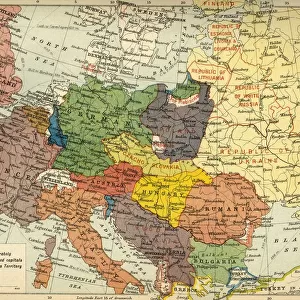
Map of Western Europe 1871

![]()
Wall Art and Photo Gifts from Fine Art Storehouse
Map of Western Europe 1871
Colton and Fitchs Introductory School Geography - New York: Sheldon and Company 1871
Unleash your creativity and transform your space into a visual masterpiece!
THEPALMER
Media ID 19834491
© 2014 Roberto Adrian Photography
FEATURES IN THESE COLLECTIONS
> Animals
> Mammals
> Muridae
> Western Mouse
> Europe
> Related Images
> Fine Art Storehouse
> Map
> Historical Maps
> Maps and Charts
> Related Images
> North America
> United States of America
> New York
> New York
> Maps
> North America
> United States of America
> New York
> Related Images
EDITORS COMMENTS
In this print titled "Map of Western Europe 1871" we are transported back in time to the late 19th century. The map, originally featured in Colton and Fitch's Introductory School Geography, takes us on a visual journey through the intricate details of Western Europe as it stood in 1871. The artist behind this remarkable piece is known simply as THEPALMER, whose talent lies not only in capturing the essence of historical maps but also preserving their beauty for generations to come. The fine art storehouse has done an exceptional job bringing this print to life, allowing us to appreciate its rich colors and intricate cartographic design. As we gaze upon the map, our eyes are drawn to the delicate lines that outline each country and region. We can almost feel the weight of history within these borders – from France with its grandeur and cultural heritage to Germany undergoing significant political changes during that era. This particular map holds a special significance as it represents a pivotal moment in European history. It captures a snapshot of nations at a time when alliances were shifting and new boundaries were being drawn following conflicts like the Franco-Prussian War. Through THEPALMER's lens, we are reminded of how geography shapes our understanding of past events and helps us comprehend their impact on societies then and now. This print serves as both an educational tool for geography enthusiasts and a beautiful work of art that transports us back into an era long gone by.
MADE IN THE USA
Safe Shipping with 30 Day Money Back Guarantee
FREE PERSONALISATION*
We are proud to offer a range of customisation features including Personalised Captions, Color Filters and Picture Zoom Tools
SECURE PAYMENTS
We happily accept a wide range of payment options so you can pay for the things you need in the way that is most convenient for you
* Options may vary by product and licensing agreement. Zoomed Pictures can be adjusted in the Cart.