Home > North America > United States of America > New York > New York > Maps
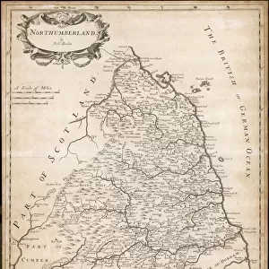
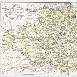
Norththumberland map 1884

![]()
Wall Art and Photo Gifts from Fine Art Storehouse
Norththumberland map 1884
Encyclopedia Britannica 9th Edition New York Charles Scribners and Sonsl 1884 Vol XVII
Unleash your creativity and transform your space into a visual masterpiece!
THEPALMER
Media ID 14549443
© This content is subject to copyright
FEATURES IN THESE COLLECTIONS
> Europe
> United Kingdom
> England
> Maps
> Europe
> United Kingdom
> England
> York
> Europe
> United Kingdom
> Maps
> Fine Art Storehouse
> Map
> Historical Maps
> Maps and Charts
> Early Maps
> North America
> United States of America
> New York
> New York
> Maps
EDITORS COMMENTS
This print showcases a piece of history frozen in time - the Northumberland map from the 1884 Encyclopedia Britannica's 9th Edition. With its intricate details and vintage charm, this artwork takes us back to an era when cartography was both an art form and a scientific endeavor. The map, meticulously crafted by Charles Scribners and Sons in New York, offers a fascinating glimpse into England's northernmost county. The Northumberland map is not just a geographical representation; it tells stories of ancient castles, picturesque landscapes, and bustling towns that have shaped the region over centuries. As we explore every inch of this beautifully preserved artifact through THEPALMER's lens, we are transported to an era where exploration was celebrated and maps were treasured possessions. The fine craftsmanship captured in this print allows us to appreciate the dedication and skill required to create such detailed cartographic masterpieces. Each contour line, river bend, or city dot is brought to life with remarkable clarity. It serves as a reminder of how far our understanding of geography has come since those early days. Whether you're an avid historian or simply drawn to nostalgic beauty, this Northumberland map print is sure to captivate your imagination. Display it proudly on your wall as a testament to human curiosity and the enduring power of artistry throughout history.
MADE IN THE USA
Safe Shipping with 30 Day Money Back Guarantee
FREE PERSONALISATION*
We are proud to offer a range of customisation features including Personalised Captions, Color Filters and Picture Zoom Tools
SECURE PAYMENTS
We happily accept a wide range of payment options so you can pay for the things you need in the way that is most convenient for you
* Options may vary by product and licensing agreement. Zoomed Pictures can be adjusted in the Cart.