Home > Arts > Street art graffiti > Digital art > Vector illustrations
Pomona California US City Street Map

![]()
Wall Art and Photo Gifts from Fine Art Storehouse
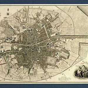
Pomona California US City Street Map
Vector Illustration of a City Street Map of Pomona, California, USA. Scale 1:60, 000.
All source data is in the public domain.
U.S. Geological Survey, US Topo
Used Layers:
USGS The National Map: National Hydrography Dataset (NHD)
USGS The National Map: National Transportation Dataset (NTD)
Unleash your creativity and transform your space into a visual masterpiece!
Frank Ramspott
Media ID 15055091
© Frank Ramspott, all rights reserved
Aerial View California City Map Computer Graphic Directly Above Downtown District Gray Road Map Text Digitally Generated Image Green Color Pomona White Color
FEATURES IN THESE COLLECTIONS
> Aerial Photography
> Related Images
> Animals
> Insects
> Hemiptera
> Green Scale
> Animals
> Mammals
> Cricetidae
> California Mouse
> Arts
> Contemporary art
> Digital artwork
> Street art
> Arts
> Landscape paintings
> Waterfall and river artworks
> River artworks
> Arts
> Portraits
> Pop art gallery
> Street art portraits
> Arts
> Street art graffiti
> Digital art
> Digital paintings
> Arts
> Street art graffiti
> Digital art
> Vector illustrations
> Fine Art Storehouse
> Map
> Street Maps
> Fine Art Storehouse
> Map
> USA Maps
> Maps and Charts
> Geological Map
> Maps and Charts
> Related Images
EDITORS COMMENTS
This print showcases a meticulously detailed city street map of Pomona, California, USA. With a scale of 1:60,000, every intricate feature is beautifully illustrated in this vector illustration. The source data used for creating this masterpiece is from the public domain and provided by the U. S. Geological Survey's National Map. The map includes various layers that contribute to its accuracy and richness. The National Hydrography Dataset (NHD) ensures precise depiction of water bodies like Puddingstone Reservoir and rivers flowing through the city. Meanwhile, the National Transportation Dataset (NTD) guarantees an accurate representation of roads and streets within Pomona. From its bustling downtown district to serene lakeside areas, this artwork captures all aspects of Pomona's urban landscape. The digitally generated image offers an aerial view directly above the city, allowing viewers to explore every nook and cranny with ease. In shades of gray, green, blue, and white colors with accompanying text labels for enhanced clarity; this visually appealing cartography design by Frank Ramspott is a testament to his expertise in computer graphics and map creation. A perfect addition to any art collection or as a gift for geography enthusiasts or residents of Pomona alike; this print brings together both artistic flair and geographical precision into one stunning piece without featuring any people - focusing solely on showcasing the physical geography that defines this vibrant Californian city.
MADE IN THE USA
Safe Shipping with 30 Day Money Back Guarantee
FREE PERSONALISATION*
We are proud to offer a range of customisation features including Personalised Captions, Color Filters and Picture Zoom Tools
SECURE PAYMENTS
We happily accept a wide range of payment options so you can pay for the things you need in the way that is most convenient for you
* Options may vary by product and licensing agreement. Zoomed Pictures can be adjusted in the Cart.