Home > Arts > Street art graffiti > Digital art > Vector illustrations
Garden Grove California US City Street Map

![]()
Wall Art and Photo Gifts from Fine Art Storehouse
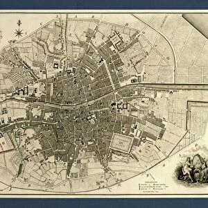
Garden Grove California US City Street Map
Vector Illustration of a City Street Map of Garden Grove, California, USA. Scale 1:60, 000.
All source data is in the public domain.
U.S. Geological Survey, US Topo
Used Layers:
USGS The National Map: National Hydrography Dataset (NHD)
USGS The National Map: National Transportation Dataset (NTD)
Unleash your creativity and transform your space into a visual masterpiece!
Frank Ramspott
Media ID 15055127
© Frank Ramspott, all rights reserved
Aerial View California City Map Computer Graphic Directly Above Downtown District Gray Road Map Text Digitally Generated Image Garden Grove Green Color White Color
FEATURES IN THESE COLLECTIONS
> Aerial Photography
> Related Images
> Animals
> Insects
> Hemiptera
> Green Scale
> Animals
> Mammals
> Cricetidae
> California Mouse
> Arts
> Contemporary art
> Digital artwork
> Street art
> Arts
> Landscape paintings
> Waterfall and river artworks
> River artworks
> Arts
> Portraits
> Pop art gallery
> Street art portraits
> Arts
> Street art graffiti
> Digital art
> Digital paintings
> Arts
> Street art graffiti
> Digital art
> Vector illustrations
> Fine Art Storehouse
> Map
> Street Maps
> Fine Art Storehouse
> Map
> USA Maps
> Maps and Charts
> Geological Map
> Maps and Charts
> Related Images
EDITORS COMMENTS
This print showcases a detailed and visually stunning city street map of Garden Grove, California, USA. The vector illustration captures the essence of this vibrant city with its downtown district, Santa Ana River, lake, and numerous streets that weave through the town. Created at a scale of 1:60,000, this artwork is meticulously designed using various layers from USGS The National Map including the National Hydrography Dataset (NHD) and the National Transportation Dataset (NTD). The image is a digitally generated masterpiece by talented artist Frank Ramspott who skillfully combines cartography and design to create an aerial view directly above Garden Grove. With no people in sight, this color image highlights the physical geography of the area with text displayed in gray against a backdrop of green colors representing lush landscapes. Blue shades symbolize water bodies while white represents roads on this comprehensive road map. It's worth noting that all source data used for this creation are in the public domain courtesy of U. S Geological Survey's US Topo project. This exceptional piece offers viewers an opportunity to appreciate both the artistic beauty and practical functionality of maps as it seamlessly blends computer graphics with real-world locations. Whether you're a resident or visitor to Garden Grove or simply have an appreciation for fine art and cartography, this print is sure to captivate your imagination.
MADE IN THE USA
Safe Shipping with 30 Day Money Back Guarantee
FREE PERSONALISATION*
We are proud to offer a range of customisation features including Personalised Captions, Color Filters and Picture Zoom Tools
SECURE PAYMENTS
We happily accept a wide range of payment options so you can pay for the things you need in the way that is most convenient for you
* Options may vary by product and licensing agreement. Zoomed Pictures can be adjusted in the Cart.