Home > Arts > Street art graffiti > Digital art > Vector illustrations
Escondido California US City Street Map

![]()
Wall Art and Photo Gifts from Fine Art Storehouse
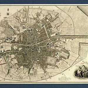
Escondido California US City Street Map
Vector Illustration of a City Street Map of Escondido, California, USA. Scale 1:60, 000.
All source data is in the public domain.
U.S. Geological Survey, US Topo
Used Layers:
USGS The National Map: National Hydrography Dataset (NHD)
USGS The National Map: National Transportation Dataset (NTD)
Unleash your creativity and transform your space into a visual masterpiece!
Frank Ramspott
Media ID 15055097
© Frank Ramspott, all rights reserved
Aerial View California City Map Computer Graphic Directly Above Downtown District Gray Road Map Text Digitally Generated Image Escondido Green Color White Color
FEATURES IN THESE COLLECTIONS
> Aerial Photography
> Related Images
> Animals
> Insects
> Hemiptera
> Green Scale
> Animals
> Mammals
> Cricetidae
> California Mouse
> Arts
> Contemporary art
> Digital artwork
> Street art
> Arts
> Landscape paintings
> Waterfall and river artworks
> River artworks
> Arts
> Portraits
> Pop art gallery
> Street art portraits
> Arts
> Street art graffiti
> Digital art
> Digital paintings
> Arts
> Street art graffiti
> Digital art
> Vector illustrations
> Fine Art Storehouse
> Map
> Street Maps
> Fine Art Storehouse
> Map
> USA Maps
> Maps and Charts
> Geological Map
> Maps and Charts
> Related Images
EDITORS COMMENTS
This print showcases a meticulously detailed city street map of Escondido, California, USA. With a scale of 1:60,000, every intricate feature is beautifully illustrated in this vector image. The artwork encompasses the downtown district with its bustling streets and vibrant atmosphere. A river gracefully meanders through the landscape while a serene lake adds to the scenic beauty of this Californian gem. The artist has skillfully utilized various layers from trusted sources such as USGS The National Map: National Hydrography Dataset (NHD) and USGS The National Map: National Transportation Dataset (NTD). These reliable data sets ensure accuracy and authenticity in depicting the city's hydrography and transportation networks. Rendered in stunning colors including shades of gray, green, blue, and white; this digitally generated image offers an aerial view directly above Escondido. It effortlessly combines elements of cartography and design to create a visually striking piece that captures the essence of this charming town. With no people present in the scene, attention is solely focused on appreciating the physical geography and layout of Escondido. This print by Frank Ramspott is not only aesthetically pleasing but also serves as an informative tool for locals or visitors alike who wish to explore every corner of this remarkable city.
MADE IN THE USA
Safe Shipping with 30 Day Money Back Guarantee
FREE PERSONALISATION*
We are proud to offer a range of customisation features including Personalised Captions, Color Filters and Picture Zoom Tools
SECURE PAYMENTS
We happily accept a wide range of payment options so you can pay for the things you need in the way that is most convenient for you
* Options may vary by product and licensing agreement. Zoomed Pictures can be adjusted in the Cart.