Home > North America > United States of America > Wyoming > Cheyenne
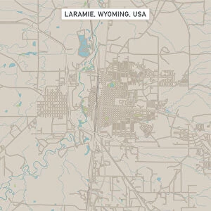
Cheyenne Wyoming US City Street Map

![]()
Wall Art and Photo Gifts from Fine Art Storehouse
Cheyenne Wyoming US City Street Map
Vector Illustration of a City Street Map of Cheyenne, Wyoming, USA. Scale 1:60, 000.
All source data is in the public domain.
U.S. Geological Survey, US Topo
Used Layers:
USGS The National Map: National Hydrography Dataset (NHD)
USGS The National Map: National Transportation Dataset (NTD)
Unleash your creativity and transform your space into a visual masterpiece!
Frank Ramspott
Media ID 15054939
© Frank Ramspott, all rights reserved
Aerial View City Map Computer Graphic Directly Above Downtown District Gray Road Map Text Wyoming Cheyenne Digitally Generated Image Green Color White Color
FEATURES IN THESE COLLECTIONS
> Aerial Photography
> Related Images
> Animals
> Insects
> Hemiptera
> Green Scale
> Arts
> Landscape paintings
> Waterfall and river artworks
> River artworks
> Arts
> Portraits
> Pop art gallery
> Street art portraits
> Fine Art Storehouse
> Map
> Street Maps
> Fine Art Storehouse
> Map
> USA Maps
> Maps and Charts
> Geological Map
> North America
> United States of America
> Lakes
> Related Images
> North America
> United States of America
> Maps
> North America
> United States of America
> Wyoming
> Cheyenne
EDITORS COMMENTS
This print showcases a meticulously detailed vector illustration of the vibrant city street map of Cheyenne, Wyoming, USA. With a scale of 1:60,000, every intricate aspect of this charming town is beautifully depicted. The source data used for this artwork is in the public domain and comes from reputable sources such as the U. S. Geological Survey and US Topo. The layers utilized to create this masterpiece include the USGS National Hydrography Dataset (NHD) and National Transportation Dataset (NTD), ensuring accuracy and precision in representing the city's hydrography and transportation networks. From its bustling downtown district to serene lakes and rivers that grace its landscape, every element has been thoughtfully incorporated into this visually stunning composition. The roads wind through the city like lifelines connecting neighborhoods while highlighting key landmarks along the way. With an aerial view directly above, this digitally generated image captures Cheyenne's essence with striking colors including shades of gray, blue, white, and green. The text adds an informative touch without overwhelming the overall design. Created by talented artist Frank Ramspott exclusively for Fine Art Storehouse, this print offers a unique perspective on Cheyenne's physical geography through modern cartography techniques. It serves as both a decorative piece for any space and an educational tool showcasing one of America's charming cities.
MADE IN THE USA
Safe Shipping with 30 Day Money Back Guarantee
FREE PERSONALISATION*
We are proud to offer a range of customisation features including Personalised Captions, Color Filters and Picture Zoom Tools
SECURE PAYMENTS
We happily accept a wide range of payment options so you can pay for the things you need in the way that is most convenient for you
* Options may vary by product and licensing agreement. Zoomed Pictures can be adjusted in the Cart.