Home > North America > United States of America > Wyoming > Casper
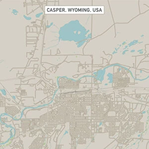
Casper Wyoming US City Street Map

![]()
Wall Art and Photo Gifts from Fine Art Storehouse
Casper Wyoming US City Street Map
Vector Illustration of a City Street Map of Casper, Wyoming, USA. Scale 1:60, 000.
All source data is in the public domain.
U.S. Geological Survey, US Topo
Used Layers:
USGS The National Map: National Hydrography Dataset (NHD)
USGS The National Map: National Transportation Dataset (NTD)
Unleash your creativity and transform your space into a visual masterpiece!
Frank Ramspott
Media ID 15054937
© Frank Ramspott, all rights reserved
Aerial View City Map Computer Graphic Directly Above Downtown District Gray Road Map Text Wyoming Casper Digitally Generated Image Green Color Soda Lake White Color
FEATURES IN THESE COLLECTIONS
> Aerial Photography
> Related Images
> Animals
> Insects
> Hemiptera
> Green Scale
> Arts
> Landscape paintings
> Waterfall and river artworks
> River artworks
> Arts
> Portraits
> Pop art gallery
> Street art portraits
> Fine Art Storehouse
> Map
> Street Maps
> Fine Art Storehouse
> Map
> USA Maps
> Maps and Charts
> Geological Map
> North America
> United States of America
> Lakes
> Soda Lake
> North America
> United States of America
> Maps
> North America
> United States of America
> Wyoming
> Casper
EDITORS COMMENTS
This print showcases a meticulously detailed vector illustration of the charming city street map of Casper, Wyoming, USA. With a scale of 1:60,000, every intricate aspect is brought to life in this visually stunning artwork. The source data used for this creation is all in the public domain and comes from reputable sources such as the U. S. Geological Survey and US Topo. The various layers utilized include USGS The National Map's National Hydrography Dataset (NHD) and National Transportation Dataset (NTD), ensuring accuracy and precision throughout the depiction. From Soda Lake to downtown district, from rivers to streets, every element that defines Casper's landscape can be admired in this design. Digitally generated with impeccable attention to detail, this image offers an aerial view directly above the cityscape. The color palette includes shades of gray, blue, white, and green which beautifully complement each other against a backdrop of physical geography. With no people present in the scene but text strategically placed for easy navigation purposes, this artwork serves both aesthetic and functional purposes. Created by Frank Ramspott exclusively for Fine Art Storehouse, it exemplifies exceptional cartography skills combined with artistic flair.
MADE IN THE USA
Safe Shipping with 30 Day Money Back Guarantee
FREE PERSONALISATION*
We are proud to offer a range of customisation features including Personalised Captions, Color Filters and Picture Zoom Tools
SECURE PAYMENTS
We happily accept a wide range of payment options so you can pay for the things you need in the way that is most convenient for you
* Options may vary by product and licensing agreement. Zoomed Pictures can be adjusted in the Cart.