Home > Animals > Birds > Gruiformes > Rallidae > Water Rail
MA Middlesex Waltham Vector Road Map

![]()
Wall Art and Photo Gifts from Fine Art Storehouse
MA Middlesex Waltham Vector Road Map
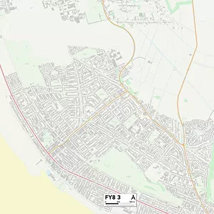
MA Middlesex Waltham Vector Road Map. All source data is in the public domain. U.S. Census Bureau Census Tiger. Used Layers: areawater, linearwater, roads, rails, cousub, pointlm, uac10
Unleash your creativity and transform your space into a visual masterpiece!
Frank Ramspott
Media ID 20690983
© Frank Ramspott, all rights reserved
City Map Computer Graphic County Digital Composite District Geographical Border Kingston Massachusetts Middlesex Road Map Text Vector Bemis Cedarwood Digitally Generated Image Lakeview Mount Tabor Riverview Waltham
FEATURES IN THESE COLLECTIONS
> Animals
> Birds
> Gruiformes
> Rallidae
> Water Rail
> Animals
> Mammals
> Cats (Wild)
> Tiger
> Arts
> Landscape paintings
> Waterfall and river artworks
> River artworks
> Arts
> Portraits
> Pop art gallery
> Street art portraits
> Arts
> Street art graffiti
> Digital art
> Digital paintings
> Europe
> United Kingdom
> England
> Middlesex
> Related Images
> Fine Art Storehouse
> Map
> Reference Maps
> Maps and Charts
> Related Images
> North America
> United States of America
> Massachusetts
> Cambridge
MA Middlesex Waltham Vector Road Map - A Stunning Digital Masterpiece by Frank Ramspott
EDITORS COMMENTS
. Immerse yourself in the intricate beauty of this digitally generated image, showcasing the MA Middlesex Waltham Vector Road Map. Designed with precision and attention to detail, this artwork is a testament to the artistry of cartography. Using layers sourced from public domain data provided by the U. S. Census Bureau Census Tiger, Ramspott skillfully blends various elements such as roads, rails, water bodies, and geographical borders to create a visually striking composition. The vibrant colors bring life to every street and town depicted on this map. While devoid of human presence, this print captures the essence of Massachusetts' Middlesex County district with its carefully labeled cities and towns including Waltham and Cambridge Reservoir. From Riverview to Lakeview, Bemis to Kingston, each location is meticulously outlined for easy navigation. The inclusion of rivers and lakes adds an extra dimension to this digital composite – a reminder of nature's influence on urban landscapes. As you explore Mount Tabor or Cedarwood through your eyes alone, you'll appreciate how physical geography shapes our surroundings. Ideal for both decorative purposes and practical use as a road map reference tool, this stunning artwork seamlessly combines form with function. Whether displayed in an office space or at home, it serves as a constant reminder of our interconnectedness within these cityscapes. With "MA Middlesex Waltham Vector Road Map". Frank Ramsp
MADE IN THE USA
Safe Shipping with 30 Day Money Back Guarantee
FREE PERSONALISATION*
We are proud to offer a range of customisation features including Personalised Captions, Color Filters and Picture Zoom Tools
SECURE PAYMENTS
We happily accept a wide range of payment options so you can pay for the things you need in the way that is most convenient for you
* Options may vary by product and licensing agreement. Zoomed Pictures can be adjusted in the Cart.