Home > Animals > Birds > Gruiformes > Rallidae > Chestnut Rail
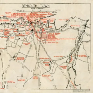
MA Middlesex Groton Vector Road Map

![]()
Wall Art and Photo Gifts from Fine Art Storehouse
MA Middlesex Groton Vector Road Map
MA Middlesex Groton Vector Road Map. All source data is in the public domain. U.S. Census Bureau Census Tiger. Used Layers: areawater, linearwater, roads, rails, cousub, pointlm, uac10
Unleash your creativity and transform your space into a visual masterpiece!
Frank Ramspott
Media ID 20691173
© Frank Ramspott, all rights reserved
City Map Computer Graphic County Digital Composite District Geographical Border Massachusetts Middlesex Road Map Text Vector Ayer Chestnut Hill Digitally Generated Image Groton Mount Lebanon
FEATURES IN THESE COLLECTIONS
> Animals
> Birds
> Gruiformes
> Rallidae
> Chestnut Rail
> Animals
> Birds
> Gruiformes
> Rallidae
> Water Rail
> Animals
> Mammals
> Cats (Wild)
> Tiger
> Arts
> Landscape paintings
> Waterfall and river artworks
> River artworks
> Arts
> Portraits
> Pop art gallery
> Street art portraits
> Arts
> Street art graffiti
> Digital art
> Digital paintings
> Europe
> United Kingdom
> England
> Middlesex
> Related Images
> Fine Art Storehouse
> Map
> Reference Maps
> Maps and Charts
> Related Images
EDITORS COMMENTS
This vibrant and detailed print showcases the MA Middlesex Groton Vector Road Map, a stunning piece of cartography created by Frank Ramspott. With all source data in the public domain, this map is an accurate representation of the area's physical geography and geographical borders. The design of this digitally generated image is visually captivating, featuring a colorful array of city streets, rivers, lakes, and text labels. It provides a comprehensive overview of key locations such as Chestnut Hill, Ayer, Vose, Mount Lebanon, East Pepperell, and Woodsville. Perfect for those with an interest in maps or anyone looking to explore the Middlesex Groton region in Massachusetts, this print offers both aesthetic appeal and practicality. The use of vector graphics ensures sharpness and clarity even when zoomed in. With no people present in the image itself but rather focusing solely on the intricate details of roads and landmarks that define this area's landscape. This digital composite seamlessly combines various layers including areawater, linearwater, rails, cousub, and pointlm from U. S Census Bureau Census Tiger data sources. Whether you're seeking to decorate your home or office space with a visually striking yet informative piece or simply appreciate fine cartography artistry, this MA Middlesex Groton Vector Road Map print is sure to captivate viewers' attention while providing valuable geographic insights into one specific region within Massachusetts.
MADE IN THE USA
Safe Shipping with 30 Day Money Back Guarantee
FREE PERSONALISATION*
We are proud to offer a range of customisation features including Personalised Captions, Color Filters and Picture Zoom Tools
SECURE PAYMENTS
We happily accept a wide range of payment options so you can pay for the things you need in the way that is most convenient for you
* Options may vary by product and licensing agreement. Zoomed Pictures can be adjusted in the Cart.