Home > Animals > Reptiles > Snakes > Rattlesnake > Tiger Rattlesnake
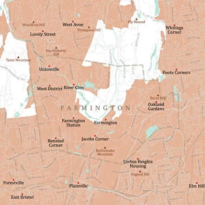
MA Franklin New Salem Vector Road Map

![]()
Wall Art and Photo Gifts from Fine Art Storehouse
MA Franklin New Salem Vector Road Map
MA Franklin New Salem Vector Road Map. All source data is in the public domain. U.S. Census Bureau Census Tiger. Used Layers: areawater, linearwater, roads, rails, cousub, pointlm, uac10
Unleash your creativity and transform your space into a visual masterpiece!
Frank Ramspott
Media ID 20690061
© Frank Ramspott, all rights reserved
City Map Computer Graphic County Digital Composite District Franklin Geographical Border Massachusetts Road Map Text Vector Digitally Generated Image Pelham Petersham Wendell
FEATURES IN THESE COLLECTIONS
> Animals
> Birds
> Gruiformes
> Rallidae
> Water Rail
> Animals
> Mammals
> Cats (Wild)
> Tiger
> Animals
> Reptiles
> Snakes
> Rattlesnake
> Tiger Rattlesnake
> Arts
> Landscape paintings
> Waterfall and river artworks
> River artworks
> Arts
> Portraits
> Pop art gallery
> Street art portraits
> Arts
> Street art graffiti
> Digital art
> Digital paintings
> Fine Art Storehouse
> Map
> Reference Maps
> Maps and Charts
> Related Images
EDITORS COMMENTS
This print showcases the MA Franklin New Salem Vector Road Map, a stunning piece of cartography art. Created by Frank Ramspott, this digitally generated image beautifully combines various layers including areawater, linearwater, roads, rails, cousub, pointlm, and uac10 from the U. S. Census Bureau Census Tiger database. The vibrant colors and intricate details bring this map to life as it highlights the physical geography of Massachusetts' Franklin County district. With no people in sight, the focus is solely on the meticulously designed city map that encompasses towns such as Franklin and New Salem. As you explore this visually appealing artwork further, your eyes will be drawn to significant landmarks like Quabbin Reservoir and Mount Lincoln. The meandering rivers and serene lakes add an element of tranquility to the composition while text labels guide your journey through each street and town. Frank Ramspott's digital composite seamlessly blends geographical borders with computer graphics resulting in a truly unique representation of this region. This print serves not only as a decorative piece but also as an informative tool for those interested in exploring or studying Massachusetts' Franklin County
MADE IN THE USA
Safe Shipping with 30 Day Money Back Guarantee
FREE PERSONALISATION*
We are proud to offer a range of customisation features including Personalised Captions, Color Filters and Picture Zoom Tools
SECURE PAYMENTS
We happily accept a wide range of payment options so you can pay for the things you need in the way that is most convenient for you
* Options may vary by product and licensing agreement. Zoomed Pictures can be adjusted in the Cart.