Home > Animals > Birds > Gruiformes > Rallidae > Water Rail
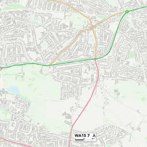
MA Franklin Hawley Vector Road Map

![]()
Wall Art and Photo Gifts from Fine Art Storehouse
MA Franklin Hawley Vector Road Map
MA Franklin Hawley Vector Road Map. All source data is in the public domain. U.S. Census Bureau Census Tiger. Used Layers: areawater, linearwater, roads, rails, cousub, pointlm, uac10
Unleash your creativity and transform your space into a visual masterpiece!
Frank Ramspott
Media ID 20690051
© Frank Ramspott, all rights reserved
City Map Computer Graphic County Digital Composite District Franklin Geographical Border Massachusetts Road Map Text Vector Charlemont Digitally Generated Image Forge Hill Hawley Watson
FEATURES IN THESE COLLECTIONS
> Animals
> Birds
> Gruiformes
> Rallidae
> Water Rail
> Animals
> Mammals
> Cats (Wild)
> Tiger
> Arts
> Landscape paintings
> Waterfall and river artworks
> River artworks
> Arts
> Portraits
> Pop art gallery
> Street art portraits
> Arts
> Street art graffiti
> Digital art
> Digital paintings
> Fine Art Storehouse
> Map
> Reference Maps
> Maps and Charts
> Related Images
EDITORS COMMENTS
This print showcases the MA Franklin Hawley Vector Road Map, a stunning piece of cartography art created by Frank Ramspott. The artist has skillfully designed this digitally generated image using various layers sourced from public domain data, including U. S. Census Bureau Census Tiger. The map encompasses the entire state of Massachusetts, highlighting its diverse geographical features and intricate road network. With vibrant colors and precise detailing, it beautifully captures the physical geography of the region, featuring rivers, lakes, towns, cities, and districts. While devoid of any human presence in the photograph itself, this artwork speaks volumes about the interconnectedness of communities within Massachusetts. From bustling city streets to serene countryside roads like Hallockville or Forge Hill - every path is meticulously depicted with utmost accuracy. Notable landmarks such as Hawks Mountain or Mount Institute are also clearly marked on this comprehensive map. It serves as an invaluable resource for both locals and visitors alike who seek to navigate through Franklin County's charming towns like Charlemont or Parker Hill. With its clean lines and clear typography indicating street names and other relevant information, this visually appealing vector map effortlessly combines aesthetics with functionality. This digital composite truly exemplifies Frank Ramspott's mastery in creating captivating cartographic designs that transcend mere utility to become works of art in their own right.
MADE IN THE USA
Safe Shipping with 30 Day Money Back Guarantee
FREE PERSONALISATION*
We are proud to offer a range of customisation features including Personalised Captions, Color Filters and Picture Zoom Tools
SECURE PAYMENTS
We happily accept a wide range of payment options so you can pay for the things you need in the way that is most convenient for you
* Options may vary by product and licensing agreement. Zoomed Pictures can be adjusted in the Cart.