Home > Animals > Reptiles > Snakes > Rattlesnake > Tiger Rattlesnake
MA Berkshire Stockbridge Vector Road Map

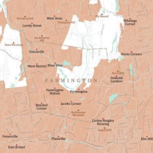
![]()
Wall Art and Photo Gifts from Fine Art Storehouse
MA Berkshire Stockbridge Vector Road Map
MA Berkshire Stockbridge Vector Road Map. All source data is in the public domain. U.S. Census Bureau Census Tiger. Used Layers: areawater, linearwater, roads, rails, cousub, pointlm, uac10
Unleash your creativity and transform your space into a visual masterpiece!
Frank Ramspott
Media ID 20688765
© Frank Ramspott, all rights reserved
Berkshire City Map Computer Graphic County Digital Composite District Geographical Border Interlaken Massachusetts Road Map Text Vector Digitally Generated Image Glendale Lenox Stockbridge Tanglewood
FEATURES IN THESE COLLECTIONS
> Animals
> Birds
> Gruiformes
> Rallidae
> Water Rail
> Animals
> Mammals
> Cats (Wild)
> Tiger
> Animals
> Reptiles
> Snakes
> Rattlesnake
> Tiger Rattlesnake
> Arts
> Landscape paintings
> Waterfall and river artworks
> River artworks
> Arts
> Portraits
> Pop art gallery
> Street art portraits
> Arts
> Street art graffiti
> Digital art
> Digital paintings
> Europe
> United Kingdom
> England
> Berkshire
> Related Images
> Fine Art Storehouse
> Map
> Reference Maps
> Maps and Charts
> Related Images
EDITORS COMMENTS
This print showcases the intricate and detailed MA Berkshire Stockbridge Vector Road Map. Designed by Frank Ramspott, this digitally generated image combines various layers of public domain data from the U. S. Census Bureau Census Tiger, including areawater, linearwater, roads, rails, cousub, pointlm, and uac10. The vibrant colors and sharp lines bring to life the physical geography of Massachusetts' Berkshire County district. From bustling cities to serene towns nestled along rivers and lakes, every geographical border is meticulously depicted in this computer graphic masterpiece. With no people present in the image itself, the focus remains solely on the artistry of cartography. The text labels seamlessly guide viewers through notable landmarks such as Glendale, Interlaken, Lenox's Mahkeenac Heights, West Stockbridge's Tanglewood and Rattlesnake Hill. Other prominent locations like Lee and Williamsville also find their place on this comprehensive road map. Perfect for those with an appreciation for both design and geography enthusiasts alike; this print adds a touch of elegance to any space it graces. Whether displayed in a study or office setting or used as a reference tool for travel planning purposes - its versatility knows no bounds
MADE IN THE USA
Safe Shipping with 30 Day Money Back Guarantee
FREE PERSONALISATION*
We are proud to offer a range of customisation features including Personalised Captions, Color Filters and Picture Zoom Tools
SECURE PAYMENTS
We happily accept a wide range of payment options so you can pay for the things you need in the way that is most convenient for you
* Options may vary by product and licensing agreement. Zoomed Pictures can be adjusted in the Cart.