Home > Asia > China > Maps
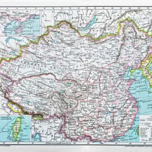
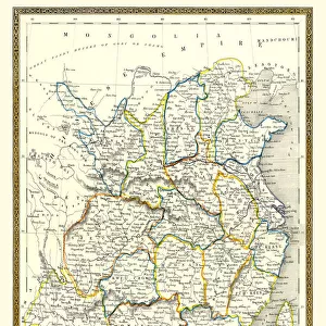
East China map 1896

![]()
Wall Art and Photo Gifts from Fine Art Storehouse
East China map 1896
Andres Allgemeiner Handatlas - Bielefeld und Leipzig 1896
Unleash your creativity and transform your space into a visual masterpiece!
THEPALMER
Media ID 18356981
FEATURES IN THESE COLLECTIONS
> Fine Art Storehouse
> Map
> Historical Maps
> Maps and Charts
> Early Maps
EDITORS COMMENTS
This print showcases a remarkable piece of history: the East China map from 1896, sourced from Andres Allgemeiner Handatlas - Bielefeld und Leipzig. A true testament to the artistry and precision of cartography during that era, this exquisite map offers a glimpse into the past, allowing us to explore the intricate details of East China as it stood over a century ago. The fine craftsmanship evident in this print is truly awe-inspiring. Every contour, river, and city has been meticulously rendered with utmost accuracy and attention to detail. The delicate lines and vibrant colors bring life to this vintage masterpiece, transporting us back in time when maps were not just navigational tools but works of art themselves. As we delve deeper into this historic document, we can uncover fascinating insights about East China's geography at the turn of the 19th century. From bustling cities like Shanghai and Hangzhou to vast landscapes dotted with mountains and rivers, every element on this map tells a story waiting to be discovered. Whether you are an avid historian or simply appreciate beautiful artwork, this print by THEPALMER is sure to captivate your imagination. It serves as a visual reminder of how far we have come in our understanding of geography while honoring the skillful craftsmanship that went into creating such magnificent pieces of cartographic art.
MADE IN THE USA
Safe Shipping with 30 Day Money Back Guarantee
FREE PERSONALISATION*
We are proud to offer a range of customisation features including Personalised Captions, Color Filters and Picture Zoom Tools
SECURE PAYMENTS
We happily accept a wide range of payment options so you can pay for the things you need in the way that is most convenient for you
* Options may vary by product and licensing agreement. Zoomed Pictures can be adjusted in the Cart.