Home > Maps and Charts > Americas
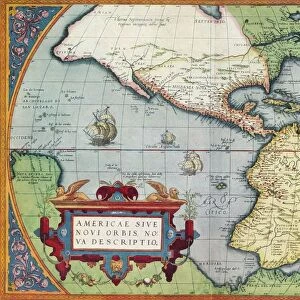
Antique world map with South and North America in the center

![]()
Wall Art and Photo Gifts from Fine Art Storehouse
Antique world map with South and North America in the center
World map with South and North America in the center
Original edition from my own archives
Source: America New World Empires 1671
Unleash your creativity and transform your space into a visual masterpiece!
Grafissimo
Media ID 18356567
FEATURES IN THESE COLLECTIONS
> Fine Art Storehouse
> Map
> Historical Maps
> Maps and Charts
> Early Maps
> Maps and Charts
> World
> North America
> Related Images
EDITORS COMMENTS
This print showcases an antique world map that takes us back in time to a bygone era. With South and North America prominently placed at the center, this unique piece offers a fascinating perspective on how the world was perceived in 1671. The original edition, carefully preserved from Grafissimo's personal archives, adds an extra layer of authenticity and historical significance to this remarkable artwork. The intricate details of this map are truly awe-inspiring. Every contour, coastline, and mountain range has been meticulously drawn with precision and artistry. It is as if we can almost feel the cartographer's hand gracefully tracing each line on parchment paper centuries ago. As we gaze upon this masterpiece, our imagination transports us to a time when exploration and discovery were at their peak. We envision brave sailors setting sail across vast oceans, embarking on perilous journeys to chart uncharted territories. This print serves as a testament to human curiosity and the relentless pursuit of knowledge throughout history. It reminds us of our collective heritage as citizens of a diverse planet interconnected by shared histories and cultures. Whether displayed in your study or living room, this antique world map will undoubtedly become a conversation starter for all who lay eyes upon it. Its timeless beauty captures the essence of exploration while honoring the rich tapestry of civilizations that have shaped our modern world.
MADE IN THE USA
Safe Shipping with 30 Day Money Back Guarantee
FREE PERSONALISATION*
We are proud to offer a range of customisation features including Personalised Captions, Color Filters and Picture Zoom Tools
SECURE PAYMENTS
We happily accept a wide range of payment options so you can pay for the things you need in the way that is most convenient for you
* Options may vary by product and licensing agreement. Zoomed Pictures can be adjusted in the Cart.