Home > Europe > Russia > Volgograd
European Russia

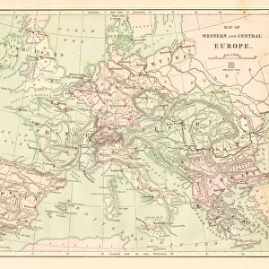
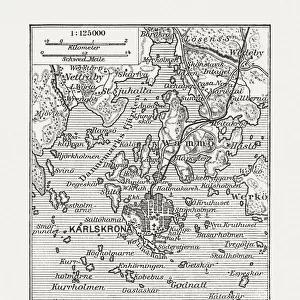
![]()
Wall Art and Photo Gifts from Fine Art Storehouse
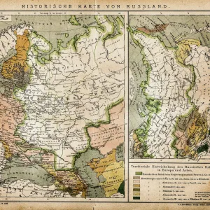
European Russia
Antique illustration of a European Russia
Unleash your creativity and transform your space into a visual masterpiece!
Nastasic
Media ID 13593305
© Nikola Nastasic
1830 1839 78279 95839 Baltic Countries Baltic Sea Biological Culture Black Sea Chart Crimea Eastern Europe Equipment Geographical Locations Image Created 1830 1839 Image Date Moscow Moscow Russia Navigational Equipment Provinces Russia Russian Culture South Caucasus Styles Ukraine Image Created 19th Century Novgorod Obsolete Retro Styled Transcaucasia Victorian Style Volgograd
FEATURES IN THESE COLLECTIONS
> Fine Art Storehouse
> The Magical World of Illustration
> Nastasic Images & Illustrations
> Fine Art Storehouse
> Map
> Historical Maps
> Maps and Charts
> Early Maps
> Maps and Charts
> World
EDITORS COMMENTS
This print takes us back in time to the enchanting era of 19th-century Europe. A true testament to the artistry of cartography, this antique illustration showcases European Russia in all its retro-styled glory. Created between 1830 and 1839, this image exudes a sense of history and nostalgia that transports us to a bygone era. The intricate details and Victorian style of this map invite exploration as we trace our fingers along the provinces, from Novgorod to Volgograd. The Baltic Sea glistens with its azure beauty while Transcaucasia beckons with its allure. As we delve deeper into the image's rich tapestry, Russian culture unfolds before our eyes, revealing stories of old and forgotten traditions. From Moscow's grandeur to Crimea's mystique, every corner holds a tale waiting to be discovered. The Baltic countries stand proud alongside Eastern Europe as geographical locations intertwine on this navigational chart from yesteryears. The Black Sea whispers secrets only known by those who have sailed its waters. As we admire this obsolete yet timeless piece of art, it serves as a reminder not only of the past but also of how cultures evolve over time. It captures an essence that transcends mere boundaries and invites us to appreciate the diversity that exists within our world. Nastasic has masterfully preserved history through his lens, allowing us to witness European Russia through the eyes of those who came before us. This print is more than just an
MADE IN THE USA
Safe Shipping with 30 Day Money Back Guarantee
FREE PERSONALISATION*
We are proud to offer a range of customisation features including Personalised Captions, Color Filters and Picture Zoom Tools
SECURE PAYMENTS
We happily accept a wide range of payment options so you can pay for the things you need in the way that is most convenient for you
* Options may vary by product and licensing agreement. Zoomed Pictures can be adjusted in the Cart.