Home > Europe > United Kingdom > Northern Ireland > Maps
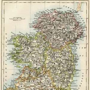
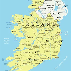
Antique map of Ireland

Wall Art and Photo Gifts from Fine Art Storehouse
Antique map of Ireland
Antique map of Ireland, 1864
Unleash your creativity and transform your space into a visual masterpiece!
duncan1890
Media ID 13666655
© duncan1890
1860 1869 Bad Condition Image Created 1860 1869 Irish Culture Navigational Equipment Northern Ireland Past Republic Of Ireland Retro Revival Styles Traditional Culture Image Created 19th Century Obsolete Retro Styled Victorian Style
FEATURES IN THESE COLLECTIONS
> Europe
> Republic of Ireland
> Maps
> Europe
> United Kingdom
> Maps
> Europe
> United Kingdom
> Northern Ireland
> Maps
> Fine Art Storehouse
> Map
> Historical Maps
> Maps and Charts
> Early Maps
EDITORS COMMENTS
This print showcases an antique map of Ireland, dating back to the year 1864. With its retro revival and 19th-century style, this image takes us on a journey through time, immersing us in the rich history and traditional culture of the Emerald Isle. Despite its bad condition due to age, this engraved image holds immense value as a relic from the past. The Victorian-style map depicts both Northern Ireland and the Republic of Ireland, reminding us of their intertwined histories. It serves as a testament to Irish heritage and offers insights into navigational equipment used during that era. Photographed by Duncan1890 for Fine Art Storehouse, this vertical composition beautifully captures every intricate detail of the map. The absence of people allows viewers to focus solely on appreciating the artistry behind it. As we gaze upon this piece, we are transported back in time – a nostalgic reminder of how cultures evolve over centuries. This photograph not only preserves an important part of Irish history but also pays homage to cartography as an art form. With its retro-styled charm and timeless appeal, this antique map print is sure to captivate anyone with an appreciation for history or those seeking a unique addition to their collection.
MADE IN THE USA
Safe Shipping with 30 Day Money Back Guarantee
FREE PERSONALISATION*
We are proud to offer a range of customisation features including Personalised Captions, Color Filters and Picture Zoom Tools
SECURE PAYMENTS
We happily accept a wide range of payment options so you can pay for the things you need in the way that is most convenient for you
* Options may vary by product and licensing agreement. Zoomed Pictures can be adjusted in the Cart.