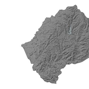
Fine Art Print : Lesotho, Relief Map With Border and Mask


![]()
Fine Art Prints From Universal Images Group (UIG)
Lesotho, Relief Map With Border and Mask
Relief map of Lesotho (with border and mask). This image was compiled from data acquired by landsat 5 & 7 satellites combined with elevation data
Universal Images Group (UIG) manages distribution for many leading specialist agencies worldwide
Media ID 9618909
© Planet Observer/UIG
Africa Lesotho Relief Map South Africa Maseru Satellite View
20"x16" (+3" Border) Fine Art Print
Discover the beauty and complexity of Lesotho with our Fine Art Print from Media Storehouse, featuring a captivating relief map. Meticulously crafted from satellite data acquired by Landsat 5 & 7, this print showcases the intricate topography of this stunning African country. The addition of its distinct border and cultural mask design adds an authentic and intriguing touch. Bring the rich history and natural wonders of Lesotho into your home or office with this unique and visually striking piece of art.
20x16 image printed on 26x22 Fine Art Rag Paper with 3" (76mm) white border. Our Fine Art Prints are printed on 300gsm 100% acid free, PH neutral paper with archival properties. This printing method is used by museums and art collections to exhibit photographs and art reproductions.
Our fine art prints are high-quality prints made using a paper called Photo Rag. This 100% cotton rag fibre paper is known for its exceptional image sharpness, rich colors, and high level of detail, making it a popular choice for professional photographers and artists. Photo rag paper is our clear recommendation for a fine art paper print. If you can afford to spend more on a higher quality paper, then Photo Rag is our clear recommendation for a fine art paper print.
Estimated Image Size (if not cropped) is 50.8cm x 36cm (20" x 14.2")
Estimated Product Size is 66cm x 55.9cm (26" x 22")
These are individually made so all sizes are approximate
Artwork printed orientated as per the preview above, with landscape (horizontal) orientation to match the source image.
EDITORS COMMENTS
This print showcases the stunning relief map of Lesotho, a landlocked country nestled within South Africa. The intricate details and vibrant colors bring to life the topography and physical geography of this African nation. Compiled from data acquired by Landsat 5 & 7 satellites, combined with elevation data, this image offers a unique perspective on Lesotho's diverse landscape. The border and mask surrounding the relief map add an artistic touch, enhancing its visual appeal. With no people in sight, the focus remains solely on nature's grandeur as it unfolds across the terrain. From towering mountains to rolling hills and vast plains, every contour is meticulously captured in this horizontal photograph. Cartography enthusiasts will appreciate how this satellite view provides valuable insights into Lesotho's geographical features. The color image allows for easy interpretation of various landforms and elevations present throughout the country. Whether used for educational purposes or personal enjoyment, this print serves as a remarkable testament to both technological advancements in satellite imagery and the beauty found within our natural world
MADE IN THE USA
Safe Shipping with 30 Day Money Back Guarantee
FREE PERSONALISATION*
We are proud to offer a range of customisation features including Personalised Captions, Color Filters and Picture Zoom Tools
SECURE PAYMENTS
We happily accept a wide range of payment options so you can pay for the things you need in the way that is most convenient for you
* Options may vary by product and licensing agreement. Zoomed Pictures can be adjusted in the Basket.