Fine Art Print > Arts > Artists > R > Roman Roman
Fine Art Print : World Map c. 50AD


![]()
Fine Art Prints from Mary Evans Picture Library
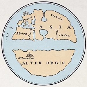
World Map c. 50AD
World Map as known to Pomponius Mela, Roman geographer
Mary Evans Picture Library makes available wonderful images created for people to enjoy over the centuries
Media ID 570594
© Mary Evans Picture Library 2015 - https://copyrighthub.org/s0/hub1/creation/maryevans/MaryEvansPictureID/10001186
Flammarion Geographer Maps Mela Pomponius
20"x16" (+3" Border) Fine Art Print
Discover the intriguing world of ancient geography with our exquisite selection of Fine Art Prints from Mary Evans Picture Library. This captivating print depicts a World Map as known to Pomponius Mela, the renowned Roman geographer around 50AD. Immerse yourself in the rich history of cartography as you explore the mysteries of the ancient world. Each print is meticulously reproduced with the highest quality standards, ensuring a stunning addition to your home or office decor. Travel back in time and expand your horizons with the Media Storehouse range of Fine Art Prints.
20x16 image printed on 26x22 Fine Art Rag Paper with 3" (76mm) white border. Our Fine Art Prints are printed on 300gsm 100% acid free, PH neutral paper with archival properties. This printing method is used by museums and art collections to exhibit photographs and art reproductions.
Our fine art prints are high-quality prints made using a paper called Photo Rag. This 100% cotton rag fibre paper is known for its exceptional image sharpness, rich colors, and high level of detail, making it a popular choice for professional photographers and artists. Photo rag paper is our clear recommendation for a fine art paper print. If you can afford to spend more on a higher quality paper, then Photo Rag is our clear recommendation for a fine art paper print.
Estimated Image Size (if not cropped) is 45.5cm x 40.6cm (17.9" x 16")
Estimated Product Size is 66cm x 55.9cm (26" x 22")
These are individually made so all sizes are approximate
Artwork printed orientated as per the preview above, with landscape (horizontal) orientation to match the source image.
FEATURES IN THESE COLLECTIONS
> Arts
> Artists
> R
> Roman Roman
> Maps and Charts
> Early Maps
> Maps and Charts
> Related Images
> Maps and Charts
> World
EDITORS COMMENTS
This stunning print captures a glimpse of the world as known to Pomponius Mela, a Roman geographer, around 50AD. The intricate details and historical significance of this early 1st-century map are truly mesmerizing. As we study the lines and markings on this ancient map, we can't help but feel transported back in time to an era when exploration and discovery were at the forefront of human endeavors.
The World Map c. 50AD is a testament to the ingenuity and curiosity of our ancestors, who sought to understand and navigate the vast expanse of our planet. It serves as a reminder of how far we have come in terms of cartography and geographical knowledge.
As we gaze upon this remarkable piece of history, we are reminded that there is still so much left to explore and uncover about our world. The intricacies of this Roman map offer us a window into the past, allowing us to appreciate the advancements made by civilizations long gone.
Mary Evans Picture Library has beautifully captured the essence of this historical artifact in their photo print, preserving it for future generations to admire and learn from. This image serves as a valuable reminder of our shared human history and the endless possibilities that lie ahead in our quest for knowledge and understanding.
MADE IN THE USA
Safe Shipping with 30 Day Money Back Guarantee
FREE PERSONALISATION*
We are proud to offer a range of customisation features including Personalised Captions, Color Filters and Picture Zoom Tools
SECURE PAYMENTS
We happily accept a wide range of payment options so you can pay for the things you need in the way that is most convenient for you
* Options may vary by product and licensing agreement. Zoomed Pictures can be adjusted in the Cart.