Fine Art Print > Maps and Charts > Early Maps
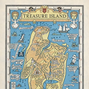
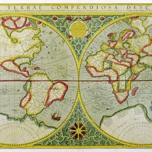
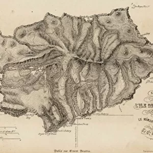
Fine Art Print : Treasure Island Map


Fine Art Prints from Mary Evans Picture Library
Treasure Island Map
A map of the island
Mary Evans Picture Library makes available wonderful images created for people to enjoy over the centuries
Media ID 606411
© Mary Evans Picture Library 2015 - https://copyrighthub.org/s0/hub1/creation/maryevans/MaryEvansPictureID/10055895
21"x14" (+3" Border) Fine Art Print
Discover the enchanting world of adventure with our exquisite range of Fine Art Prints from Media Storehouse, featuring this captivating Treasure Island Map by Mary Evans Picture Library from Mary Evans Prints Online. Each print is meticulously reproduced from original sources, ensuring the highest quality and authenticity. Transport yourself to the mystical lands of Long John Silver and buried treasure with this stunning, vintage map as your guide. A perfect addition to any home or office, these Fine Art Prints make for a timeless and captivating decor piece.
21x14 image printed on 27x20 Fine Art Rag Paper with 3" (76mm) white border. Our Fine Art Prints are printed on 300gsm 100% acid free, PH neutral paper with archival properties. This printing method is used by museums and art collections to exhibit photographs and art reproductions.
Our fine art prints are high-quality prints made using a paper called Photo Rag. This 100% cotton rag fibre paper is known for its exceptional image sharpness, rich colors, and high level of detail, making it a popular choice for professional photographers and artists. Photo rag paper is our clear recommendation for a fine art paper print. If you can afford to spend more on a higher quality paper, then Photo Rag is our clear recommendation for a fine art paper print.
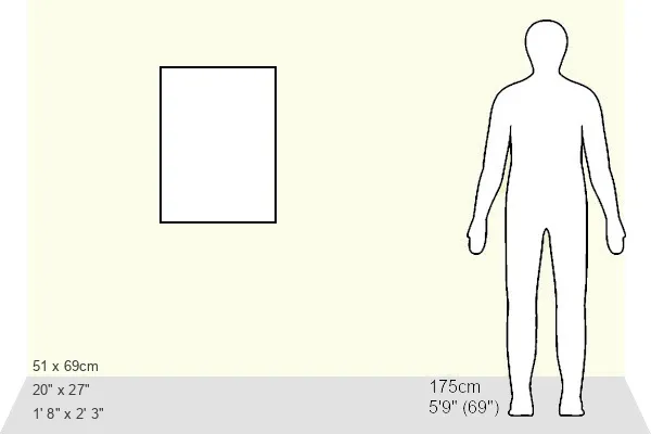
Estimated Image Size (if not cropped) is 35.5cm x 53.3cm (14" x 21")
Estimated Product Size is 50.8cm x 68.6cm (20" x 27")
These are individually made so all sizes are approximate
Artwork printed orientated as per the preview above, with portrait (vertical) orientation to match the source image.
FEATURES IN THESE COLLECTIONS
> Maps and Charts
> Early Maps
> Maps and Charts
> Related Images
EDITORS COMMENTS
1. Title: "The Legendary Treasure Island Map: A Window into 19th-Century Imagination" This antique print showcases a rare and intriguing depiction of Robert Louis Stevenson's Treasure Island map. Published in 1883, this map is a visual representation of the famed pirate hideout, as described in Stevenson's classic novel, "Treasure Island." The map, a rich tapestry of historical intrigue and adventure, is a testament to the power of storytelling and the enduring allure of pirate lore. With its hand-drawn details and meticulous annotations, this map invites us to embark on a journey to a time when treasure hunts, pirate legends, and the thrill of discovery were the stuff of dreams. Stevenson's "Treasure Island," first published in 1883, is a novel that has captivated readers for generations. The story follows the adventures of young Jim Hawkins, who sets sail on the Hispaniola with the infamous pirate Long John Silver in search of buried treasure. The novel's vivid descriptions of the Treasure Island map and its hidden treasures have fueled the imaginations of countless readers and inspired countless adaptations. This historical map, a precious relic from the era of Stevenson's publication, offers a unique glimpse into the world of "Treasure Island" and the rich literary and historical context from which it emerged. With its intricate details and evocative imagery, this map is a must-have for any collector of rare books, historical maps, or pirate lore. In conclusion, this Treasure Island map print is not just a beautiful and intriguing piece of art, but a window into the 19th-century imagination and the enduring legacy of Robert Louis Stevenson's classic novel.
MADE IN THE USA
Safe Shipping with 30 Day Money Back Guarantee
FREE PERSONALISATION*
We are proud to offer a range of customisation features including Personalised Captions, Color Filters and Picture Zoom Tools
SECURE PAYMENTS
We happily accept a wide range of payment options so you can pay for the things you need in the way that is most convenient for you
* Options may vary by product and licensing agreement. Zoomed Pictures can be adjusted in the Cart.