Fine Art Print > Europe > United Kingdom > England > London > Transport > Railway
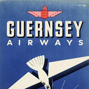
Fine Art Print : Guernsey Airways Poster


![]()
Fine Art Prints from Mary Evans Picture Library
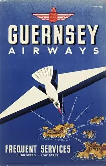
Guernsey Airways Poster
Guernsey Airways Ltd, poster giving a stylised route map of flights from London and Southampton to Channel Islands, and Dinard on the French coast.
20th century
Mary Evans Picture Library makes available wonderful images created for people to enjoy over the centuries
Media ID 7474538
© Mary Evans Picture Library 2015 - https://copyrighthub.org/s0/hub1/creation/maryevans/MaryEvansPictureID/10609944
Airways Alderney Channel Dinard Flights Guernsey Jersey Route Services Southampton Spartan Stylised Aeronautics
21"x14" (+3" Border) Fine Art Print
Experience the charm of aviation history with our exquisite selection from the Media Storehouse range of Fine Art Prints. This captivating Guernsey Airways poster, originally created by The Royal Aeronautical Society (National Aerospace Library) and available through Mary Evans Prints Online, showcases a stylized route map of flights from London, Southampton, and Dinard to the Channel Islands during the 20th century. Each print is meticulously reproduced to preserve the authentic details and vibrant colors, making it a stunning addition to your home or office. Transport yourself back in time with this elegant piece of aviation heritage.
21x14 image printed on 27x20 Fine Art Rag Paper with 3" (76mm) white border. Our Fine Art Prints are printed on 300gsm 100% acid free, PH neutral paper with archival properties. This printing method is used by museums and art collections to exhibit photographs and art reproductions.
Our fine art prints are high-quality prints made using a paper called Photo Rag. This 100% cotton rag fibre paper is known for its exceptional image sharpness, rich colors, and high level of detail, making it a popular choice for professional photographers and artists. Photo rag paper is our clear recommendation for a fine art paper print. If you can afford to spend more on a higher quality paper, then Photo Rag is our clear recommendation for a fine art paper print.
Estimated Image Size (if not cropped) is 35.5cm x 53.3cm (14" x 21")
Estimated Product Size is 50.8cm x 68.6cm (20" x 27")
These are individually made so all sizes are approximate
Artwork printed orientated as per the preview above, with portrait (vertical) orientation to match the source image.
FEATURES IN THESE COLLECTIONS
> Europe
> United Kingdom
> England
> London
> Related Images
> Europe
> United Kingdom
> England
> London
> Transport
> Railway
> Maps and Charts
> Related Images
> Popular Themes
> Railway Posters
> Mary Evans Prints Online
> Royal Aeronautical Society
EDITORS COMMENTS
This vibrant and stylish poster, created by Guernsey Airways Ltd in the 20th century, showcases the aeronautical services connecting London, Southampton, and the Channel Islands to Dinard on the French coast. The poster's design is a testament to the excitement and glamour of air travel during this era. The central focus of the poster is a stylised map of the routes, with London and Southampton depicted as key departure points. The Channel Islands, represented by Jersey and Alderney, are shown as idyllic green islands nestled in the English Channel. The route to Dinard in France is illustrated as a graceful yellow line, evoking the feeling of flight and the journey across the sea. The poster's color palette is dominated by green and yellow, reflecting the natural beauty of the islands and the spirit of adventure. The Spartan aircraft, a symbol of the era's aeronautics, is depicted soaring above the map, adding to the sense of motion and freedom. The poster also highlights the connection between rail and air travel, with a railway train shown in the bottom left corner, emphasizing the seamless integration of transport services. The poster's text, written in bold, clear font, promotes the convenience and frequency of the flights, inviting passengers to explore the Channel Islands and France by air. This poster is a fascinating glimpse into the history of aviation and travel during the 20th century, showcasing the allure and excitement of flying to far-off destinations. The Royal Aeronautical Society's National Aerospace Library has preserved this important piece of aeronautical history, making it available for us to appreciate and learn from today.
MADE IN THE USA
Safe Shipping with 30 Day Money Back Guarantee
FREE PERSONALISATION*
We are proud to offer a range of customisation features including Personalised Captions, Color Filters and Picture Zoom Tools
SECURE PAYMENTS
We happily accept a wide range of payment options so you can pay for the things you need in the way that is most convenient for you
* Options may vary by product and licensing agreement. Zoomed Pictures can be adjusted in the Cart.