Fine Art Print > Arts > Artists > T > Isaac Taylor
Fine Art Print : Map of the Americas, circa 1821

![]()
Fine Art Prints from Mary Evans Picture Library
Map of the Americas, circa 1821
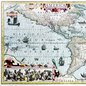
Map of the Americas, circa 1821. Showing Labrador, Canada, the United States, Louisiana, Mexico, Brazil, Amazonia, Paraguay, etc. Handcoloured copperplate engraving from Rev. Isaac Taylors Scenes in America, for the Amusement and Instruction of Little Tarry-at-Home Travelers, John Harris, London, 1821
Mary Evans Picture Library makes available wonderful images created for people to enjoy over the centuries
Media ID 23391624
© Florilegius
1821 Americas Amusement Feather Headdress Instruction Isaac Tarry Taylor Title Vignette
20"x20" (+3" Border) Fine Art Print
Discover the captivating beauty of the past with our exquisite selection of Fine Art Prints from Media Storehouse. This stunning Map of the Americas, circa 1821, sourced from the esteemed Mary Evans Picture Library, offers a mesmerizing glimpse into the historical geography of the New World. Handcoloured copperplate engraving from a rare and revered publication, this intricately detailed map showcases the territories of Labrador, Canada, the United States, Louisiana, Mexico, Brazil, Amazonia, Paraguay, and more. Elevate your home or office decor with this timeless piece of cartographic art, a captivating conversation starter, and a testament to the rich history of exploration and discovery.
20x20 image printed on 26x26 Fine Art Rag Paper with 3" (76mm) white border. Our Fine Art Prints are printed on 300gsm 100% acid free, PH neutral paper with archival properties. This printing method is used by museums and art collections to exhibit photographs and art reproductions.
Our fine art prints are high-quality prints made using a paper called Photo Rag. This 100% cotton rag fibre paper is known for its exceptional image sharpness, rich colors, and high level of detail, making it a popular choice for professional photographers and artists. Photo rag paper is our clear recommendation for a fine art paper print. If you can afford to spend more on a higher quality paper, then Photo Rag is our clear recommendation for a fine art paper print.
Estimated Image Size (if not cropped) is 50.8cm x 47cm (20" x 18.5")
Estimated Product Size is 66cm x 66cm (26" x 26")
These are individually made so all sizes are approximate
Artwork printed orientated as per the preview above, with landscape (horizontal) orientation to match the source image.
FEATURES IN THESE COLLECTIONS
> Arts
> Artists
> T
> Isaac Taylor
> Europe
> United Kingdom
> England
> London
> Related Images
> Maps and Charts
> Related Images
> North America
> Canada
> Maps
> North America
> Canada
> Related Images
> North America
> Mexico
> Maps
> North America
> Mexico
> Related Images
> South America
> Brazil
> Maps
> South America
> Brazil
> Related Images
> Mary Evans Prints Online
> New Images August 2021
EDITORS COMMENTS
This map print, titled "Scenes in America" and dated circa 1821, offers a fascinating glimpse into the geographical knowledge of the Americas during the early 19th century. The intricately detailed copperplate engraving, produced by the renowned English publisher John Harris, showcases the vast expanse of North and South America, from Labrador in Canada to the tip of South America. The map is adorned with vibrant handcoloring, adding depth and richness to the various territories and regions depicted. Notable areas include the United States, Louisiana, Mexico, Brazil, Amazonia, and Paraguay. The map also highlights the Mississippi River, the Great Lakes, and the Rio de la Plata. The map is surrounded by a decorative border featuring a Native American woman wearing a feather headdress and cradling a child. This vignette adds an element of culture and education to the print, providing a visual representation of the diverse indigenous populations that inhabited the Americas at the time. The map is an essential historical artifact, reflecting the geographical knowledge and understanding of the world during the early 1800s. It serves as a testament to the advancements in cartography and the growing interest in exploration and discovery during this period. The intricate detail and beautiful handcoloring make this map a captivating addition to any collection focused on history, geography, or art.
MADE IN THE USA
Safe Shipping with 30 Day Money Back Guarantee
FREE PERSONALISATION*
We are proud to offer a range of customisation features including Personalised Captions, Color Filters and Picture Zoom Tools
SECURE PAYMENTS
We happily accept a wide range of payment options so you can pay for the things you need in the way that is most convenient for you
* Options may vary by product and licensing agreement. Zoomed Pictures can be adjusted in the Cart.