Fine Art Print > Maps and Charts > British Empire Maps
Fine Art Print : World Map Empire McVitie


Fine Art Prints from Mary Evans Picture Library
World Map Empire McVitie
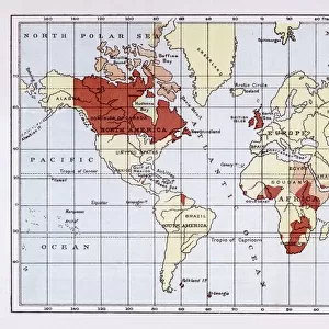
A map of the world, showing the British Empire coloured in red at the end of the nineteenth century
Mary Evans Picture Library makes available wonderful images created for people to enjoy over the centuries
Media ID 592741
© Mary Evans Picture Library 2015 - https://copyrighthub.org/s0/hub1/creation/maryevans/MaryEvansPictureID/10041931
Colonialism Dominions Imperialism Maps Mcvitie Patriotism Power Territory
20"x16" (+3" Border) Fine Art Print
Discover the rich history of the British Empire with our stunning Fine Art Print from Mary Evans Picture Library. This captivating World Map, titled "Empire McVitie," transports you back in time to the late 19th century, showcasing the extensive reach of the British Empire in bold red hues. Add an air of sophistication and historical depth to your home or office with this exquisite print. Order now and let the stories of exploration and conquest unfold before your eyes.
20x16 image printed on 26x22 Fine Art Rag Paper with 3" (76mm) white border. Our Fine Art Prints are printed on 300gsm 100% acid free, PH neutral paper with archival properties. This printing method is used by museums and art collections to exhibit photographs and art reproductions.
Our fine art prints are high-quality prints made using a paper called Photo Rag. This 100% cotton rag fibre paper is known for its exceptional image sharpness, rich colors, and high level of detail, making it a popular choice for professional photographers and artists. Photo rag paper is our clear recommendation for a fine art paper print. If you can afford to spend more on a higher quality paper, then Photo Rag is our clear recommendation for a fine art paper print.
Estimated Image Size (if not cropped) is 50.2cm x 40.6cm (19.8" x 16")
Estimated Product Size is 66cm x 55.9cm (26" x 22")
These are individually made so all sizes are approximate
Artwork printed orientated as per the preview above, with landscape (horizontal) orientation to match the source image.
FEATURES IN THESE COLLECTIONS
> Maps and Charts
> British Empire Maps
> Maps and Charts
> Early Maps
> Maps and Charts
> Related Images
> Maps and Charts
> World
> Mary Evans Prints Online
> Maps
EDITORS COMMENTS
This striking print of the "World Map Empire McVitie" offers a glimpse into the vast and powerful British Empire at the end of the nineteenth century. The map, colored in bold red to signify British territory, showcases the extent of imperialism and colonialism during this period in history.
The map is a testament to Britain's dominance and influence across the globe, with its various dominions highlighted for all to see. It serves as a reminder of the immense power that Britain held during this time, as well as the impact it had on shaping world events.
As we study this historical artifact, we are transported back to a time when patriotism and national pride were closely tied to notions of empire building and expansion. The map symbolizes not only British strength and authority but also serves as a reflection of global politics and relationships during the late 19th century.
Through examining this map, we gain valuable insights into how historical events have shaped our world today. It is a visual representation of an era marked by ambition, conquest, and territorial control - elements that continue to resonate in our modern society.
Overall, "World Map Empire McVitie" is more than just a geographical depiction; it is a window into an important chapter in human history that continues to inform our understanding of power dynamics and international relations.
MADE IN THE USA
Safe Shipping with 30 Day Money Back Guarantee
FREE PERSONALISATION*
We are proud to offer a range of customisation features including Personalised Captions, Color Filters and Picture Zoom Tools
SECURE PAYMENTS
We happily accept a wide range of payment options so you can pay for the things you need in the way that is most convenient for you
* Options may vary by product and licensing agreement. Zoomed Pictures can be adjusted in the Cart.