Fine Art Print > Animals > Mammals > Muridae > Water Mouse
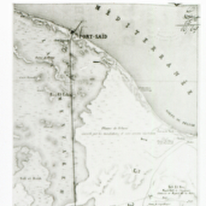
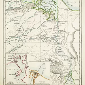
Fine Art Print : Map of the Suez Canal, Egypt

![]()
Fine Art Prints From Mary Evans Picture Library
Map of the Suez Canal, Egypt
Map of the Suez Canal in Egypt showing the water way from the Mediterranean Sea to the Red Sea which was constructed in the 19th century by the Suez Canal Company founded by Ferdinand de Lesseps. The map also illustrates most of the major travel routes in the area. Date: circa 1930
Mary Evans Picture Library makes available wonderful images created for people to enjoy over the centuries
Media ID 14403081
© Mary Evans / Pharcide
Area Canal Canals Ismailia Lakes Maps Mediterranean Route Routes Seas Suez Tewfik Track Tracks Travelling Ways
21"x14" (+3" Border) Fine Art Print
Discover the rich history of the Suez Canal with our exquisite Fine Art Print of the Map of the Suez Canal in Egypt. This captivating representation of the waterway, constructed in the late 19th century by the Suez Canal Company under the leadership of Ferdinand de Lesseps, is a testament to human engineering and geopolitical significance. Our high-quality print, sourced from Mary Evans Prints Online, brings the intricate details of this historic map to your home or office. Perfect for history enthusiasts, cartography aficionados, or anyone seeking to add a touch of sophistication to their space. Order now and let this fine art print transport you on a journey through time.
21x14 image printed on 27x20 Fine Art Rag Paper with 3" (76mm) white border. Our Fine Art Prints are printed on 300gsm 100% acid free, PH neutral paper with archival properties. This printing method is used by museums and art collections to exhibit photographs and art reproductions.
Our fine art prints are high-quality prints made using a paper called Photo Rag. This 100% cotton rag fibre paper is known for its exceptional image sharpness, rich colors, and high level of detail, making it a popular choice for professional photographers and artists. Photo rag paper is our clear recommendation for a fine art paper print. If you can afford to spend more on a higher quality paper, then Photo Rag is our clear recommendation for a fine art paper print.
Estimated Image Size (if not cropped) is 32.2cm x 53.3cm (12.7" x 21")
Estimated Product Size is 50.8cm x 68.6cm (20" x 27")
These are individually made so all sizes are approximate
Artwork printed orientated as per the preview above, with portrait (vertical) orientation to match the source image.
FEATURES IN THESE COLLECTIONS
> Africa
> Egypt
> Lakes
> Related Images
> Africa
> Egypt
> Related Images
> Animals
> Mammals
> Muridae
> Water Mouse
> Maps and Charts
> Related Images
> Popular Themes
> Railway Posters
EDITORS COMMENTS
This map print from circa 1930 showcases the Suez Canal in Egypt, an engineering marvel of the 19th century. The waterway stretches from the Mediterranean Sea to the Red Sea, connecting two major bodies of water and significantly reducing the distance and time required for international maritime travel between Europe and Asia. The intricately detailed map illustrates the Suez Canal's winding path, as it cuts through the Egyptian desert, passing by the cities of Ismailia and Port Said in the eastern and western terminals, respectively. The map also highlights the major travel routes in the area, including the railway tracks that run parallel to the canal, providing an alternative means of transportation for both people and goods. The map reveals several lakes and bodies of water in the region, such as the Bitter Lakes and the Lake Timsah, which were used as part of the canal's lock system to help regulate the water levels and facilitate the passage of ships. The map also marks various ports and anchorages along the canal, providing essential information for travelers and sailors of the time. Ferdinand de Lesseps, a French diplomat and entrepreneur, founded the Suez Canal Company in 1858, with the vision of constructing the canal to facilitate global trade and travel. The map serves as a testament to the ingenuity and ambition of the time, offering a glimpse into the rich history of maritime exploration and the development of international travel routes.
MADE IN THE USA
Safe Shipping with 30 Day Money Back Guarantee
FREE PERSONALISATION*
We are proud to offer a range of customisation features including Personalised Captions, Color Filters and Picture Zoom Tools
SECURE PAYMENTS
We happily accept a wide range of payment options so you can pay for the things you need in the way that is most convenient for you
* Options may vary by product and licensing agreement. Zoomed Pictures can be adjusted in the Basket.