Fine Art Print > Arts > Artists > O > Oceanic Oceanic
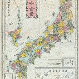
Fine Art Print : Map of Okinawa island by G. H. Davis


![]()
Fine Art Prints From Mary Evans Picture Library
Map of Okinawa island by G. H. Davis
Okinawa island, the Key to Japan, whose capital, Naha, had just fallen towards the end of the Second World War. It was a vital base for the air war on Japan. Date: 1945
Mary Evans Picture Library makes available wonderful images created for people to enjoy over the centuries
Media ID 14133519
© Illustrated London News Ltd/Mary Evans
1945 Capital Davis Fallen Okinawa Pacific Vital Base Naha
20"x16" (+3" Border) Fine Art Print
Discover the rich history and culture of Okinawa island with this stunning fine art print from Media Storehouse. This captivating map, created by G.H. Davis in 1945, depicts Okinawa at a pivotal moment in history. As the capital, Naha, fell towards the end of the Second World War, Okinawa became a crucial base for the air war on Japan. Bring this piece of history into your home or office and add a touch of sophistication and intrigue to your space. This print is available through Rights Managed licensing from Mary Evans Prints Online.
20x16 image printed on 26x22 Fine Art Rag Paper with 3" (76mm) white border. Our Fine Art Prints are printed on 300gsm 100% acid free, PH neutral paper with archival properties. This printing method is used by museums and art collections to exhibit photographs and art reproductions.
Our fine art prints are high-quality prints made using a paper called Photo Rag. This 100% cotton rag fibre paper is known for its exceptional image sharpness, rich colors, and high level of detail, making it a popular choice for professional photographers and artists. Photo rag paper is our clear recommendation for a fine art paper print. If you can afford to spend more on a higher quality paper, then Photo Rag is our clear recommendation for a fine art paper print.
Estimated Image Size (if not cropped) is 36cm x 50.8cm (14.2" x 20")
Estimated Product Size is 55.9cm x 66cm (22" x 26")
These are individually made so all sizes are approximate
Artwork printed orientated as per the preview above, with portrait (vertical) orientation to match the source image.
FEATURES IN THESE COLLECTIONS
> Arts
> Artists
> O
> Oceanic Oceanic
> Asia
> Japan
> Related Images
> Maps and Charts
> Early Maps
> Maps and Charts
> Related Images
> Maps and Charts
> World
EDITORS COMMENTS
This historic map print, created by renowned cartographer G.H. Davis in 1945, depicts Okinawa Island, a vital strategic location in the Pacific Ocean during the closing stages of the Second World War. With its capital, Naha, having recently fallen into Japanese hands, Okinawa became a crucial base for the air war on Japan. The island's location in the Eastern Pacific made it an essential link between the Japanese home islands and their southern territories, making control of Okinawa a priority for both the Allied and Japanese forces. The map provides a detailed representation of the island's geography, including its numerous islands and reefs, as well as the surrounding waters teeming with shipping lanes and naval bases. The intricate detailing of the map underscores the importance of Okinawa as a military and logistical hub during the war. The fall of Naha marked a significant turning point in the Pacific War, as it opened up the way for the Allied forces to advance towards the Japanese mainland. The Battle of Okinawa, which began in April 1945, was one of the bloodiest battles in the Pacific Theater, with estimates of over 240,000 casualties between the Allied and Japanese forces. This map serves as a poignant reminder of the historical significance of Okinawa Island during the Second World War and the pivotal role it played in the eventual defeat of Japan. Its intricate detailing and historical context make it an invaluable addition to any collection of wartime maps or Pacific War memorabilia.
MADE IN THE USA
Safe Shipping with 30 Day Money Back Guarantee
FREE PERSONALISATION*
We are proud to offer a range of customisation features including Personalised Captions, Color Filters and Picture Zoom Tools
SECURE PAYMENTS
We happily accept a wide range of payment options so you can pay for the things you need in the way that is most convenient for you
* Options may vary by product and licensing agreement. Zoomed Pictures can be adjusted in the Basket.