Fine Art Print > Asia > Malaysia > Maps
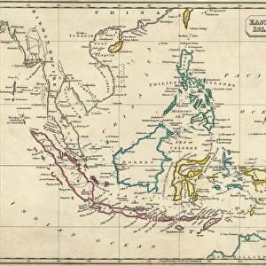
Fine Art Print : Map of Malaysia 1908


![]()
Fine Art Prints from Mary Evans Picture Library
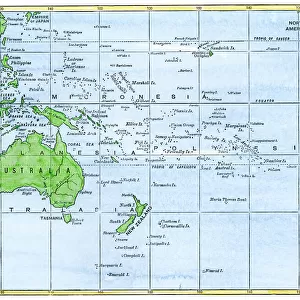
Map of Malaysia 1908
A map showing all the islands that make up Malaysia Date: 1908
Mary Evans Picture Library makes available wonderful images created for people to enjoy over the centuries
Media ID 7154381
© Mary Evans Picture Library 2015 - https://copyrighthub.org/s0/hub1/creation/maryevans/MaryEvansPictureID/10149907
Borneo Guinea Java Malaysia Maps Philippines Sumatra
21"x14" (+3" Border) Fine Art Print
Discover the rich history and cultural diversity of Malaysia with our exquisite Fine Art Prints from Media Storehouse. This captivating Map of Malaysia from 1908, sourced from Mary Evans Prints Online, offers a fascinating glimpse into the past. The intricate details of the map showcase all the islands that make up this vibrant country, making it a must-have addition to any home or office space. Our Fine Art Prints are of the highest quality, ensuring that the vibrant colors and intricate details of this historic map are preserved for generations to come. Order yours today and bring a piece of Malaysian history into your world.
21x14 image printed on 27x20 Fine Art Rag Paper with 3" (76mm) white border. Our Fine Art Prints are printed on 300gsm 100% acid free, PH neutral paper with archival properties. This printing method is used by museums and art collections to exhibit photographs and art reproductions.
Our fine art prints are high-quality prints made using a paper called Photo Rag. This 100% cotton rag fibre paper is known for its exceptional image sharpness, rich colors, and high level of detail, making it a popular choice for professional photographers and artists. Photo rag paper is our clear recommendation for a fine art paper print. If you can afford to spend more on a higher quality paper, then Photo Rag is our clear recommendation for a fine art paper print.
Estimated Image Size (if not cropped) is 53.3cm x 33.4cm (21" x 13.1")
Estimated Product Size is 68.6cm x 50.8cm (27" x 20")
These are individually made so all sizes are approximate
Artwork printed orientated as per the preview above, with landscape (horizontal) orientation to match the source image.
FEATURES IN THESE COLLECTIONS
> Asia
> Malaysia
> Related Images
> Asia
> Philippines
> Maps
> Asia
> Philippines
> Related Images
> Asia
> Related Images
> Maps and Charts
> Related Images
EDITORS COMMENTS
1. Title: "A Vintage Glimpse of Malaysia and Its Surrounding Islands: A 1908 Map Revealing the Extent of British Colonial Influence" This vintage map print, dated 1908, offers a fascinating glimpse into the geography and colonial history of Malaysia and its surrounding islands. The map, titled "Malay Peninsula and Surrounding Islands," showcases the intricate detail of the region during a pivotal period in its history. The map, produced in 1908, depicts the Malay Peninsula, Sumatra, Java, the Philippines, Borneo, New Guinea, and other islands in the region. The British colonial influence is evident, as the map highlights the administrative boundaries of various British territories, including the Straits Settlements and the Federated Malay States. The map's intricate detail extends to the depiction of numerous islands, including the Riau Archipelago, the Andaman and Nicobar Islands, and the Sulu Archipelago. The map also includes annotations indicating major cities, rivers, and other topographical features. At the time, the British had established significant colonial holdings in the region, with Penang, Singapore, and Melaka being prominent British territories. The map reflects the extent of British influence, which extended beyond the Malay Peninsula to include territories in Sumatra, Borneo, and the eastern half of New Guinea. This map print is an essential addition to any collection focusing on Malaysian history, colonialism, or cartography. Its intricate detail and historical significance make it an engaging and educational piece for both personal and academic use. The map's antique charm and historical accuracy transport us back to a time when the world was being explored and mapped with newfound precision. This map print invites us to delve deeper into the rich history of Malaysia and its surrounding islands.
MADE IN THE USA
Safe Shipping with 30 Day Money Back Guarantee
FREE PERSONALISATION*
We are proud to offer a range of customisation features including Personalised Captions, Color Filters and Picture Zoom Tools
SECURE PAYMENTS
We happily accept a wide range of payment options so you can pay for the things you need in the way that is most convenient for you
* Options may vary by product and licensing agreement. Zoomed Pictures can be adjusted in the Cart.