Fine Art Print > Europe > Spain > Related Images
Fine Art Print : Detail of map No

![]()
Fine Art Prints From Mary Evans Picture Library
Detail of map No
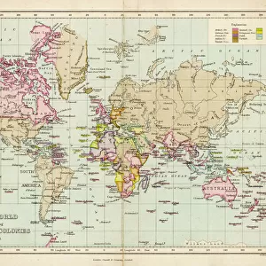
Detail of map No.6 by Robert Adams, engraved by Augustine Ryther, showing the route of the Spanish Armada fleet druing
Mary Evans Picture Library makes available wonderful images created for people to enjoy over the centuries
Media ID 8268077
© Mary Evans Picture Library 2015 - https://copyrighthub.org/s0/hub1/creation/maryevans/MaryEvansPictureID/10209163
Armada Augustine Engraved Route Aisa Ryther
21"x14" (+3" Border) Fine Art Print
Discover the rich history of the Spanish Armada with our exquisite Fine Art Prints from Media Storehouse. This captivating detail from Map No.6, engraved by Augustine Ryther and created by Robert Adams, offers a fascinating glimpse into the historic voyage of the Spanish Armada in 1588. Each print is meticulously reproduced from the original at Mary Evans Prints Online, ensuring the highest quality and authenticity. Bring the intrigue and adventure of this iconic moment in history into your home or office, and elevate your space with the timeless beauty of these fine art prints.
21x14 image printed on 27x20 Fine Art Rag Paper with 3" (76mm) white border. Our Fine Art Prints are printed on 300gsm 100% acid free, PH neutral paper with archival properties. This printing method is used by museums and art collections to exhibit photographs and art reproductions.
Our fine art prints are high-quality prints made using a paper called Photo Rag. This 100% cotton rag fibre paper is known for its exceptional image sharpness, rich colors, and high level of detail, making it a popular choice for professional photographers and artists. Photo rag paper is our clear recommendation for a fine art paper print. If you can afford to spend more on a higher quality paper, then Photo Rag is our clear recommendation for a fine art paper print.
Estimated Image Size (if not cropped) is 35.5cm x 53.3cm (14" x 21")
Estimated Product Size is 50.8cm x 68.6cm (20" x 27")
These are individually made so all sizes are approximate
Artwork printed orientated as per the preview above, with portrait (vertical) orientation to match the source image.
EDITORS COMMENTS
This detail of Map No. 6, titled "The Route of the Spanish Armada," offers a fascinating glimpse into a pivotal moment in European history. Engraved by Augustine Ryther and created by the renowned American photographer Robert Adams, this historical map provides an intricate and meticulously detailed representation of the journey of the Spanish Armada fleet during its ill-fated invasion of England in 1588. The Spanish Armada was a grand naval expedition, assembled by King Philip II of Spain with the intention of defeating England's naval forces and establishing Catholic supremacy in the North Sea. The fleet, comprised of over 130 ships and carrying thousands of soldiers, set sail from the Spanish port of Lisbon in May 1588. As the Spanish Armada made its way across the English Channel, it encountered a series of storms that dispersed the fleet and weakened its defenses. The English, under the command of Queen Elizabeth I and her admiral, Sir Francis Drake, seized the opportunity to launch a counter-attack. The ensuing battles, fought in the English Channel and the North Sea, resulted in the destruction of the majority of the Spanish Armada. This detailed map, created in the late 16th or early 17th century, illustrates the route of the Spanish Armada as it sailed from the Iberian Peninsula, through the English Channel, and into the North Sea. The intricate lines and annotations provide valuable information about the ports of call, wind patterns, and currents that influenced the course of the fleet. The map also includes annotations indicating the locations of key battles and engagements. This historical map is an essential resource for scholars, historians, and anyone interested in the rich and complex history of Europe during the late Renaissance period. The intricate detail and meticulous craftsmanship of the engraving by Augustine Ryther, under the direction of Robert Adams, make this a stunning and valuable addition to any collection.
MADE IN THE USA
Safe Shipping with 30 Day Money Back Guarantee
FREE PERSONALISATION*
We are proud to offer a range of customisation features including Personalised Captions, Color Filters and Picture Zoom Tools
SECURE PAYMENTS
We happily accept a wide range of payment options so you can pay for the things you need in the way that is most convenient for you
* Options may vary by product and licensing agreement. Zoomed Pictures can be adjusted in the Basket.