Fine Art Print > MapSeeker > Maps of Europe > Old Maps of Europe and Small Islands of
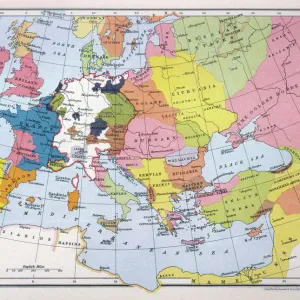
Fine Art Print : Map of Europe showing how it appeared at the time of the Restoration of the Empire in the Wwest by Otto The Great AD 962
![]()

Fine Art Prints From MapSeeker
Map of Europe showing how it appeared at the time of the Restoration of the Empire in the Wwest by Otto The Great AD 962
EHIST005
Welcome to the Mapseeker Image library and enter an historic gateway to one of the largest on-line collections of Historic Maps, Nostalgic Views, Vista's and Panorama's from a World gone by.
Media ID 20348254
Europe Europe Map Map Of Europe
20"x16" (+3" Border) Fine Art Print
Step back in time with our exquisite fine art print from Media Storehouse, featuring a captivating Map of Europe as it appeared during the Restoration of the Empire by Otto the Great in AD 962. This intricately detailed map, sourced from MapSeeker, offers a unique glimpse into European history. With its rich, vibrant colors and meticulous attention to detail, this fine art print is not only an educational treasure but also a stunning addition to any home or office decor. Transport yourself back to the Middle Ages and add a touch of history to your space with this beautiful and authentic reproduction.
20x16 image printed on 26x22 Fine Art Rag Paper with 3" (76mm) white border. Our Fine Art Prints are printed on 300gsm 100% acid free, PH neutral paper with archival properties. This printing method is used by museums and art collections to exhibit photographs and art reproductions.
Our fine art prints are high-quality prints made using a paper called Photo Rag. This 100% cotton rag fibre paper is known for its exceptional image sharpness, rich colors, and high level of detail, making it a popular choice for professional photographers and artists. Photo rag paper is our clear recommendation for a fine art paper print. If you can afford to spend more on a higher quality paper, then Photo Rag is our clear recommendation for a fine art paper print.
Estimated Image Size (if not cropped) is 48.7cm x 40.6cm (19.2" x 16")
Estimated Product Size is 66cm x 55.9cm (26" x 22")
These are individually made so all sizes are approximate
Artwork printed orientated as per the preview above, with landscape (horizontal) orientation to match the source image.
EDITORS COMMENTS
This print showcases a historical gem, the "Map of Europe showing how it appeared at the time of the Restoration of the Empire in the West by Otto The Great AD 962 (EHIST005)". This meticulously crafted map takes us back to a significant period in European history when Otto I, also known as Otto The Great, restored and consolidated his empire. The map vividly depicts Europe during this transformative era, offering an invaluable glimpse into political boundaries and cultural landscapes. From its westernmost shores to its eastern frontiers, every detail is intricately etched with precision. It allows us to trace the expansion and influence of Otto's empire across vast territories that encompassed modern-day Germany, Italy, France, Austria-Hungary, and beyond. As we immerse ourselves in this visual masterpiece, we can appreciate how borders have shifted over centuries. We witness cities flourishing under imperial rule while others emerge as key centers of trade and culture. Rivers meander through diverse landscapes connecting bustling towns and fortresses that once guarded strategic positions. This photograph preserves not only a historical artifact but also invites contemplation on Europe's rich heritage. It reminds us of our shared past and highlights how empires rise and fall throughout time. Whether you are an avid historian or simply fascinated by cartography's beauty, this remarkable print will transport you to an age where emperors shaped continents with their ambitions – leaving behind legacies that continue to shape our present world.
MADE IN THE USA
Safe Shipping with 30 Day Money Back Guarantee
FREE PERSONALISATION*
We are proud to offer a range of customisation features including Personalised Captions, Color Filters and Picture Zoom Tools
SECURE PAYMENTS
We happily accept a wide range of payment options so you can pay for the things you need in the way that is most convenient for you
* Options may vary by product and licensing agreement. Zoomed Pictures can be adjusted in the Basket.


