Fine Art Print > Europe > United Kingdom > Wales > Monmouthshire > Monmouth
Fine Art Print : Pictorial History Map of Wales and Monmouth 1966


![]()
Fine Art Prints from MapSeeker
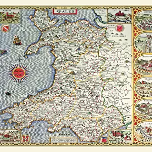
Pictorial History Map of Wales and Monmouth 1966
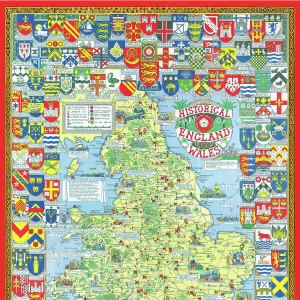
This is a wonderful pictorial map illustrating the history of Wales drawn by Leslie Bullock and published in c1966 by Collins Bartholomew as a fold up map. Now re-digitized and re-published by Mapseeker in association with the Collins Bartholomew Archive, the map covers all of Wales and Monmouth with historical locations and events illustrated pictorially in the form of charming cartoon vignettes. The map is surrounded by the armorial crests of Wales
Welcome to the Mapseeker Image library and enter an historic gateway to one of the largest on-line collections of Historic Maps, Nostalgic Views, Vista's and Panorama's from a World gone by.
Media ID 20347935
21"x14" (+3" Border) Fine Art Print
Step back in time with our exquisite Fine Art Print from Media Storehouse's collection. This captivating Pictorial History Map of Wales and Monmouth, published by Collins Bartholomew in 1966, is a masterpiece by the renowned cartographer Leslie Bullock. Each intricate detail brings the rich history of Wales to life, making this print a stunning addition to any home or office. Transport yourself to the past with this beautiful and informative piece of art. Order yours today and let history unfold before your eyes.
21x14 image printed on 27x20 Fine Art Rag Paper with 3" (76mm) white border. Our Fine Art Prints are printed on 300gsm 100% acid free, PH neutral paper with archival properties. This printing method is used by museums and art collections to exhibit photographs and art reproductions.
Our fine art prints are high-quality prints made using a paper called Photo Rag. This 100% cotton rag fibre paper is known for its exceptional image sharpness, rich colors, and high level of detail, making it a popular choice for professional photographers and artists. Photo rag paper is our clear recommendation for a fine art paper print. If you can afford to spend more on a higher quality paper, then Photo Rag is our clear recommendation for a fine art paper print.
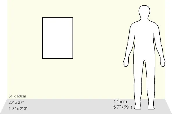
Estimated Image Size (if not cropped) is 35.5cm x 53.3cm (14" x 21")
Estimated Product Size is 50.8cm x 68.6cm (20" x 27")
These are individually made so all sizes are approximate
Artwork printed orientated as per the preview above, with portrait (vertical) orientation to match the source image.
FEATURES IN THESE COLLECTIONS
> Europe
> United Kingdom
> Wales
> Maps
> Europe
> United Kingdom
> Wales
> Monmouthshire
> Monmouth
> Europe
> United Kingdom
> Wales
> Posters
> Europe
> United Kingdom
> Wales
> Related Images
> Maps and Charts
> Early Maps
> Maps and Charts
> Related Images
> Maps and Charts
> Wales
> MapSeeker
> Maps from the British Isles
> Wales and Counties PORTFOLIO
> MapSeeker
> Pictorial Maps and Pictorial History
> Pictorial History Maps PORTFOLIO
EDITORS COMMENTS
This print showcases the "Pictorial History Map of Wales and Monmouth 1966" a remarkable piece of artistry by Leslie Bullock. Originally published as a fold-up map in collaboration with Collins Bartholomew, this historical gem has now been re-digitized and re-published by Mapseeker, in association with the esteemed Collins Bartholomew Archive. The map itself spans across the entirety of Wales and Monmouth, offering an enchanting visual narrative of their rich history. Through delightful cartoon vignettes, Bullock skillfully depicts various significant locations and events that have shaped these lands over time. Each pictorial illustration serves as a window into the past, transporting viewers to key moments in Welsh history. Surrounding the map are the armorial crests of Wales, adding an air of regality to this already impressive artwork. These heraldic symbols pay homage to Wales' proud heritage and noble lineage. While it is important to note that this print is not intended for commercial use, its true value lies in its ability to educate and inspire. Whether you are a history enthusiast or simply appreciate fine craftsmanship, this Pictorial History Map offers a unique perspective on Wales' fascinating past. With every glance at its intricate details, one can't help but be captivated by the beauty and charm encapsulated within this extraordinary piece of cartographic art.
MADE IN THE USA
Safe Shipping with 30 Day Money Back Guarantee
FREE PERSONALISATION*
We are proud to offer a range of customisation features including Personalised Captions, Color Filters and Picture Zoom Tools
SECURE PAYMENTS
We happily accept a wide range of payment options so you can pay for the things you need in the way that is most convenient for you
* Options may vary by product and licensing agreement. Zoomed Pictures can be adjusted in the Cart.