Fine Art Print > Arts > Artists > T > John Tallis
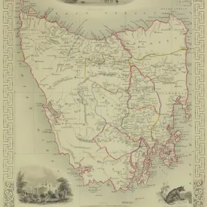
Fine Art Print : Van Diemens Island, or Tasmania 1851

![]()
Fine Art Prints From MapSeeker
Van Diemens Island, or Tasmania 1851
A fine facimile artworked from an antique original map of Van Diemens Land or Tasmania, issued as part of the 1851 edition of John Tallis and Companys " The Illustrated Atlas and Modern History of the World"
Welcome to the Mapseeker Image library and enter an historic gateway to one of the largest on-line collections of Historic Maps, Nostalgic Views, Vista's and Panorama's from a World gone by.
Media ID 20347356
© Mapseeker Publishing Ltd
John Tallis John Tallis Map Tallis Map Tasmania
21"x14" (+3" Border) Fine Art Print
Discover the rich history of Tasmania with our exquisite fine art print of Van Diemens Island, or Tasmania 1851 by John Tallis and John Rapkin from MapSeeker. This stunning reproduction is taken from an original antique map published in the 1851 edition of John Tallis and Company's "The Illustrated Atlas." The intricate detail and vibrant colors bring the early exploration of Tasmania to life, making this a beautiful addition to any home or office. Transport yourself back in time with this captivating piece of cartographical history.
21x14 image printed on 27x20 Fine Art Rag Paper with 3" (76mm) white border. Our Fine Art Prints are printed on 300gsm 100% acid free, PH neutral paper with archival properties. This printing method is used by museums and art collections to exhibit photographs and art reproductions.
Our fine art prints are high-quality prints made using a paper called Photo Rag. This 100% cotton rag fibre paper is known for its exceptional image sharpness, rich colors, and high level of detail, making it a popular choice for professional photographers and artists. Photo rag paper is our clear recommendation for a fine art paper print. If you can afford to spend more on a higher quality paper, then Photo Rag is our clear recommendation for a fine art paper print.
Estimated Image Size (if not cropped) is 35.5cm x 53.3cm (14" x 21")
Estimated Product Size is 50.8cm x 68.6cm (20" x 27")
These are individually made so all sizes are approximate
Artwork printed orientated as per the preview above, with portrait (vertical) orientation to match the source image.
FEATURES IN THESE COLLECTIONS
> Arts
> Artists
> T
> John Tallis
> Europe
> France
> Canton
> Landes
> Maps and Charts
> World
EDITORS COMMENTS
This exquisite print showcases a remarkable piece of history - an antique original map of Van Diemens Island, or Tasmania, dating back to 1851. Painstakingly reproduced as a fine facsimile artwork, this map is a testament to the rich cartographic heritage of the region. Part of John Tallis and Company's renowned "The Illustrated Atlas and Modern History of the World" this particular edition holds immense historical significance. The attention to detail in capturing every contour and coastline on this old Tasmanian map is truly awe-inspiring. As you gaze upon this image, you are transported back in time to an era when exploration was at its peak. The intricate illustrations depicting mountains, rivers, and settlements provide a fascinating glimpse into Tasmania's past. John Tallis and John Rapkin have masterfully captured the essence of Van Diemens Land through their artistry. This print serves as a window into an age when maps were not just navigational tools but also works of art that celebrated the wonders of our world. Whether you are an avid collector or simply appreciate historical artifacts, this mesmerizing depiction will undoubtedly become a cherished addition to your collection. Let it transport you to another time and place – where adventure awaited around every corner on the island now known as Tasmania.
MADE IN THE USA
Safe Shipping with 30 Day Money Back Guarantee
FREE PERSONALISATION*
We are proud to offer a range of customisation features including Personalised Captions, Color Filters and Picture Zoom Tools
SECURE PAYMENTS
We happily accept a wide range of payment options so you can pay for the things you need in the way that is most convenient for you
* Options may vary by product and licensing agreement. Zoomed Pictures can be adjusted in the Basket.