Fine Art Print > Europe > United Kingdom > England > London > Transport > Stations
Fine Art Print : Old Map of Southampton 1851 by John Tallis

![]()
Fine Art Prints From MapSeeker
Old Map of Southampton 1851 by John Tallis
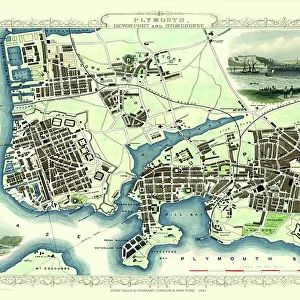
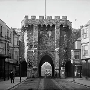
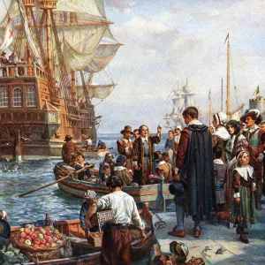
The River Itchen dominates the 1851 John Tallis plan of Southampton in Hampshire with The Parks covering a great expanse to the top left. The main illustration is a Victorian view across the shoreline to Southampton. The other three illustrations are of Netley Abbey, The Bar Gate and Railway Station at the London and South Western Railway Terminus
Welcome to the Mapseeker Image library and enter an historic gateway to one of the largest on-line collections of Historic Maps, Nostalgic Views, Vista's and Panorama's from a World gone by.
Media ID 20347588
Historic Map John Tallis John Tallis Map Old Town Plan Tallis Map
21"x14" (+3" Border) Fine Art Print
Discover the rich history of Southampton with our exquisite Old Map of Southampton 1851 by John Tallis from our Media Storehouse Fine Art Prints collection. This stunning piece of cartographical art takes you back in time, highlighting the River Itchen's significant role in the city's landscape. The expansive Parks area at the top left adds to the serene beauty of this detailed map. Bring the history and charm of Southampton into your home or office with this beautiful and authentic work of art.
21x14 image printed on 27x20 Fine Art Rag Paper with 3" (76mm) white border. Our Fine Art Prints are printed on 300gsm 100% acid free, PH neutral paper with archival properties. This printing method is used by museums and art collections to exhibit photographs and art reproductions.
Our fine art prints are high-quality prints made using a paper called Photo Rag. This 100% cotton rag fibre paper is known for its exceptional image sharpness, rich colors, and high level of detail, making it a popular choice for professional photographers and artists. Photo rag paper is our clear recommendation for a fine art paper print. If you can afford to spend more on a higher quality paper, then Photo Rag is our clear recommendation for a fine art paper print.
Estimated Image Size (if not cropped) is 35.5cm x 53.3cm (14" x 21")
Estimated Product Size is 50.8cm x 68.6cm (20" x 27")
These are individually made so all sizes are approximate
Artwork printed orientated as per the preview above, with portrait (vertical) orientation to match the source image.
FEATURES IN THESE COLLECTIONS
> Arts
> Artists
> T
> John Tallis
> Europe
> United Kingdom
> England
> Hampshire
> Netley
> Europe
> United Kingdom
> England
> Hampshire
> Park Gate
> Europe
> United Kingdom
> England
> Hampshire
> Related Images
> Europe
> United Kingdom
> England
> Hampshire
> South Town
> Europe
> United Kingdom
> England
> Hampshire
> Southampton
> Europe
> United Kingdom
> England
> London
> Transport
> Railway
> Europe
> United Kingdom
> England
> London
> Transport
> Stations
> Popular Themes
> Railway Posters
EDITORS COMMENTS
This print showcases the "Old Map of Southampton 1851" by John Tallis, offering a glimpse into the rich history and charm of this coastal town in Hampshire. The map beautifully highlights the dominance of The River Itchen, gracefully meandering through Southampton's landscape. The focal point of this Victorian illustration is an enchanting view across the shoreline to Southampton itself. One can almost imagine the bustling activity that once took place along these historic streets, as ships sailed in and out of its busy port. Accompanying this main illustration are three smaller depictions that add further depth to the narrative. Netley Abbey, with its ancient ruins standing proudly amidst lush greenery, offers a glimpse into Southampton's architectural heritage. The Bar Gate stands tall and majestic, symbolizing both protection and welcoming visitors to explore what lies beyond its walls. Lastly, we see a depiction of the Railway Station at London and South Western Railway Terminus—a testament to Southampton's importance as a transportation hub during that era. As one gazes upon this old map of Southampton, it becomes evident how much has changed over time while still preserving elements from centuries past. This piece serves as a reminder of our connection to history and invites us to appreciate how far we have come since John Tallis first captured this snapshot in 1851.
MADE IN THE USA
Safe Shipping with 30 Day Money Back Guarantee
FREE PERSONALISATION*
We are proud to offer a range of customisation features including Personalised Captions, Color Filters and Picture Zoom Tools
SECURE PAYMENTS
We happily accept a wide range of payment options so you can pay for the things you need in the way that is most convenient for you
* Options may vary by product and licensing agreement. Zoomed Pictures can be adjusted in the Basket.