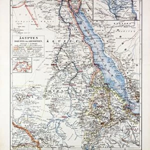
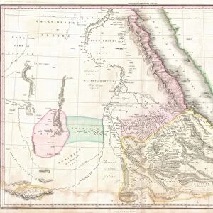
Fine Art Print : Travels in Nubia, Map, 19th century engraving, Nubia is a region along the Nile river


![]()
Fine Art Prints from Liszt Collection
Travels in Nubia, Map, 19th century engraving, Nubia is a region along the Nile river
Travels in Nubia, Map, 19th century engraving, Nubia is a region along the Nile river, which is located in northern Sudan and southern Egypt
Liszt Collection of nineteenth-century engravings and images to browse and enjoy
Media ID 12804599
© Quint Lox Limited
Located Nubia Travels Nile River
20"x16" (+3" Border) Fine Art Print
Step back in time with our exquisite Fine Art Print of the 19th century engraving, "Travels in Nubia, Map." This captivating piece transports you to the heart of ancient Nubia, a region rich in history and culture, situated along the Nile River in northern Sudan and southern Egypt. The intricate details of this antique map, from the Liszt Collection, provide a glimpse into the explorations of a bygone era. Add this stunning work of art to your collection and bring the history of Nubia into your home or office.
20x16 image printed on 26x22 Fine Art Rag Paper with 3" (76mm) white border. Our Fine Art Prints are printed on 300gsm 100% acid free, PH neutral paper with archival properties. This printing method is used by museums and art collections to exhibit photographs and art reproductions.
Our fine art prints are high-quality prints made using a paper called Photo Rag. This 100% cotton rag fibre paper is known for its exceptional image sharpness, rich colors, and high level of detail, making it a popular choice for professional photographers and artists. Photo rag paper is our clear recommendation for a fine art paper print. If you can afford to spend more on a higher quality paper, then Photo Rag is our clear recommendation for a fine art paper print.
Estimated Image Size (if not cropped) is 40.6cm x 50.8cm (16" x 20")
Estimated Product Size is 55.9cm x 66cm (22" x 26")
These are individually made so all sizes are approximate
Artwork printed orientated as per the preview above, with portrait (vertical) orientation to match the source image.
EDITORS COMMENTS
This 19th-century engraving from the Liszt Collection takes us on a visual journey through the ancient region of Nubia. The intricately detailed map showcases the enchanting landscapes and historical landmarks that define this remarkable area along the Nile River. Nubia, situated in both northern Sudan and southern Egypt, has long been revered for its rich cultural heritage and breathtaking natural beauty. As we gaze upon this print, we are transported to a time when intrepid explorers embarked on daring travels across these lands. The map provides an invaluable glimpse into the past, highlighting key cities, settlements, and waterways that were crucial to trade routes and cultural exchange. It is a testament to human ingenuity and curiosity as well as an ode to the resilience of civilizations that thrived in this challenging yet rewarding environment. Every line etched onto this engraving tells a story - stories of bustling markets filled with exotic goods, tales of ancient temples standing proudly against desert backdrops, and legends of mighty pharaohs who once ruled over these lands. As we admire this piece of artistry from centuries ago, let it serve as a reminder of our shared history and interconnectedness. May it inspire us to embark on our own journeys - whether physical or metaphorical - in search of knowledge, understanding, and appreciation for all corners of our world.
MADE IN THE USA
Safe Shipping with 30 Day Money Back Guarantee
FREE PERSONALISATION*
We are proud to offer a range of customisation features including Personalised Captions, Color Filters and Picture Zoom Tools
SECURE PAYMENTS
We happily accept a wide range of payment options so you can pay for the things you need in the way that is most convenient for you
* Options may vary by product and licensing agreement. Zoomed Pictures can be adjusted in the Cart.