Fine Art Print > Maps and Charts > Related Images
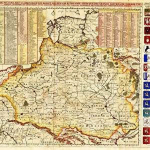
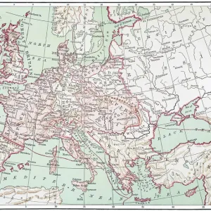
Fine Art Print : Map Tabula ducatuum Livoniae et Curlandiae recentior incisa editaque


![]()
Fine Art Prints From Liszt Collection
Map Tabula ducatuum Livoniae et Curlandiae recentior incisa editaque
Map, Tabula ducatuum Livoniae et Curlandiae recentior incisa editaque per Gerardum Valck, Gerhard Valk (-1726), Copperplate print
Liszt Collection of nineteenth-century engravings and images to browse and enjoy
Media ID 19584914
© Artokoloro
1726 Copperplate Print Gerhard Valk
20"x16" (+3" Border) Fine Art Print
Discover the captivating beauty of our Fine Art Print from Media Storehouse, featuring the intricately detailed Tabula ducatuum Livoniae et Curlandiae recentior incisa editaque map. This exquisite copperplate print, hailing from the esteemed Liszt Collection, showcases the historical territories of Livonia and Curlandia with meticulous precision. The rich textures and vibrant colors of this rare and antique map transport you back in time, making it a stunning addition to any home or office decor. Own a piece of history and elevate your space with this beautiful work of art.
20x16 image printed on 26x22 Fine Art Rag Paper with 3" (76mm) white border. Our Fine Art Prints are printed on 300gsm 100% acid free, PH neutral paper with archival properties. This printing method is used by museums and art collections to exhibit photographs and art reproductions.
Our fine art prints are high-quality prints made using a paper called Photo Rag. This 100% cotton rag fibre paper is known for its exceptional image sharpness, rich colors, and high level of detail, making it a popular choice for professional photographers and artists. Photo rag paper is our clear recommendation for a fine art paper print. If you can afford to spend more on a higher quality paper, then Photo Rag is our clear recommendation for a fine art paper print.
Estimated Image Size (if not cropped) is 48.1cm x 40.6cm (18.9" x 16")
Estimated Product Size is 66cm x 55.9cm (26" x 22")
These are individually made so all sizes are approximate
Artwork printed orientated as per the preview above, with landscape (horizontal) orientation to match the source image.
EDITORS COMMENTS
This print showcases a historical map titled "Map, Tabula ducatuum Livoniae et Curlandiae recentior incisa editaque" by Gerardum Valck, also known as Gerhard Valk. Created in 1726 using copperplate print technique, this exquisite piece of cartography offers a glimpse into the past. The map depicts the territories of Livonia and Courland, providing valuable insights into their geographical boundaries during that era. With intricate details and precise craftsmanship, Valck's work highlights his mastery in capturing the essence of these regions. As we delve into this fascinating image, we are transported back to a time when maps were not just navigational tools but works of art themselves. The delicate lines and ornate embellishments on this copperplate print reveal the dedication and skill required to create such an impressive piece. Through its rich colors and meticulous design, this print allows us to appreciate the historical significance of Livonia and Courland while marveling at Valck's artistic prowess. It serves as a reminder that maps hold stories within them – tales of exploration, conquests, and cultural heritage. Whether displayed in a study or gallery setting, this print from Liszt Collection is sure to captivate viewers with its blend of history and artistry. A true testament to human curiosity and creativity throughout centuries!
MADE IN THE USA
Safe Shipping with 30 Day Money Back Guarantee
FREE PERSONALISATION*
We are proud to offer a range of customisation features including Personalised Captions, Color Filters and Picture Zoom Tools
SECURE PAYMENTS
We happily accept a wide range of payment options so you can pay for the things you need in the way that is most convenient for you
* Options may vary by product and licensing agreement. Zoomed Pictures can be adjusted in the Basket.