Fine Art Print > Asia > Palestine > Maps
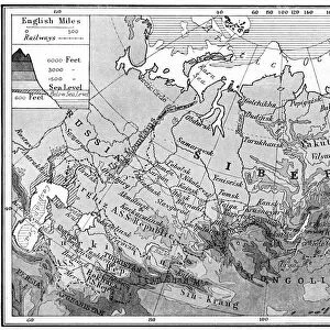
Fine Art Print : etc Bartholomew map Palestine 1900


![]()
Fine Art Prints From Liszt Collection
etc Bartholomew map Palestine 1900
etc. Bartholomews map of Palestine 1900
Liszt Collection of nineteenth-century engravings and images to browse and enjoy
Media ID 18536716
© Liszt Collection
20"x16" (+3" Border) Fine Art Print
Discover the rich history of the Holy Land with our exquisite Fine Art Print from the Liszt Collection. This captivating etchmap, titled "Bartholomew's Map of Palestine 1900," offers a fascinating glimpse into the past. With intricate detail and stunning accuracy, this vintage map transports you back in time, showcasing the geography and political landscape of the region over a century ago. A must-have for history enthusiasts, collectors, and those seeking to adorn their walls with a piece of historical art. Bring the past into your present with our Fine Art Print from the Liszt Collection.
20x16 image printed on 26x22 Fine Art Rag Paper with 3" (76mm) white border. Our Fine Art Prints are printed on 300gsm 100% acid free, PH neutral paper with archival properties. This printing method is used by museums and art collections to exhibit photographs and art reproductions.
Our fine art prints are high-quality prints made using a paper called Photo Rag. This 100% cotton rag fibre paper is known for its exceptional image sharpness, rich colors, and high level of detail, making it a popular choice for professional photographers and artists. Photo rag paper is our clear recommendation for a fine art paper print. If you can afford to spend more on a higher quality paper, then Photo Rag is our clear recommendation for a fine art paper print.
Estimated Image Size (if not cropped) is 50.8cm x 36.1cm (20" x 14.2")
Estimated Product Size is 66cm x 55.9cm (26" x 22")
These are individually made so all sizes are approximate
Artwork printed orientated as per the preview above, with landscape (horizontal) orientation to match the source image.
FEATURES IN THESE COLLECTIONS
> Asia
> Palestine
> Related Images
> Maps and Charts
> Related Images
EDITORS COMMENTS
This print showcases the remarkable "Bartholomew Map of Palestine 1900" from the prestigious Liszt Collection. Steeped in historical significance, this meticulously detailed map offers a fascinating glimpse into the intricate geography and cultural tapestry of Palestine at the turn of the century. With its rich hues and exquisite craftsmanship, this print transports viewers to a bygone era when cartography was both an art form and a vital tool for exploration. The Bartholomew Map effortlessly captures every nuance of the region's topography, highlighting mountains, rivers, cities, and villages with unparalleled precision. As we delve into this mesmerizing piece, we are transported back to a time when borders were fluid and cultures intermingled harmoniously. This map serves as a testament to human curiosity and our innate desire to understand our surroundings. The Liszt Collection has masterfully preserved this rare gem from history for all to admire. It is not only an object of beauty but also an invaluable resource for historians, researchers, or anyone seeking insight into Palestine's past. Whether you are captivated by ancient civilizations or simply appreciate fine artistry, this print will undoubtedly leave you awe-inspired. Let it adorn your walls as a reminder that knowledge knows no bounds and that even in today's fast-paced world, there is always room for reflection on our shared heritage.
MADE IN THE USA
Safe Shipping with 30 Day Money Back Guarantee
FREE PERSONALISATION*
We are proud to offer a range of customisation features including Personalised Captions, Color Filters and Picture Zoom Tools
SECURE PAYMENTS
We happily accept a wide range of payment options so you can pay for the things you need in the way that is most convenient for you
* Options may vary by product and licensing agreement. Zoomed Pictures can be adjusted in the Basket.