Fine Art Print > Europe > Portugal > Maps
Fine Art Print : World Map (Propoganda), 1529. Artist: Ribeiro, Diogo (?-1533)
, 1529. Artist: Ribeiro, Diogo (?-1533)")

![]()
Fine Art Prints From Heritage Images
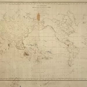
World Map (Propoganda), 1529. Artist: Ribeiro, Diogo (?-1533)
World Map (Propoganda), 1529. Found in the collection of the Biblioteca Apostolica Vaticana
Heritage Images features heritage image collections
Media ID 15015622
© Fine Art Images
Biblioteca Apostolica Vaticana Cartography Chart Ink On Parchment Nautical Chart Portolan Portolan Chart Portugal
20"x20" (+3" Border) Fine Art Print
Discover the captivating history of cartography with our exquisite offering from Media Storehouse - a Fine Art Print of Diogo Ribeiro's World Map (Propaganda), 1529. This rare and intriguing piece, sourced from the esteemed Biblioteca Apostolica Vaticana, showcases the world as it was perceived during the early 16th century. Ribeiro's masterful depiction, filled with vibrant colors and intricate details, is a testament to the rich cultural heritage of the time. Bring this stunning work of art into your home or office as a conversation starter and a reminder of the fascinating journey of cartography throughout history.
21x7 image printed on 27x13 Fine Art Rag Paper with 3" (76mm) white border. Our Fine Art Prints are printed on 300gsm 100% acid free, PH neutral paper with archival properties. This printing method is used by museums and art collections to exhibit photographs and art reproductions.
Our fine art prints are high-quality prints made using a paper called Photo Rag. This 100% cotton rag fibre paper is known for its exceptional image sharpness, rich colors, and high level of detail, making it a popular choice for professional photographers and artists. Photo rag paper is our clear recommendation for a fine art paper print. If you can afford to spend more on a higher quality paper, then Photo Rag is our clear recommendation for a fine art paper print.
Estimated Image Size (if not cropped) is 41.3cm x 17.7cm (16.3" x 7")
Estimated Product Size is 68.6cm x 33cm (27" x 13")
These are individually made so all sizes are approximate
Artwork printed orientated as per the preview above, with landscape (horizontal) orientation to match the source image.
FEATURES IN THESE COLLECTIONS
> Europe
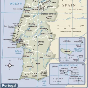
> Portugal
> Related Images
> Maps and Charts
> Related Images
> Maps and Charts
> World
EDITORS COMMENTS
This print showcases the "World Map (Propaganda)" created by Diogo Ribeiro in 1529. The artist, whose birth and death dates remain uncertain, crafted this remarkable piece that now resides in the esteemed collection of the Biblioteca Apostolica Vaticana. The map itself is a testament to Ribeiro's mastery of cartography and graphic arts. Inked on parchment with intricate details, it offers a glimpse into the world as understood during the early 16th century. With Portugal at its center, this portolan chart provides an invaluable historical record of nautical routes and geographical knowledge from that era. Ribeiro's World Map also bears elements of propaganda, reflecting the political climate of his time. It subtly promotes Portuguese exploration and colonization efforts across distant lands through carefully placed symbols and imagery. This artistic approach adds depth to an already visually stunning creation. As we admire this fine art image today, we are transported back in time to an age when maps were not just functional tools but works of art themselves. The delicate craftsmanship displayed here reminds us of humanity's enduring curiosity about our planet and our relentless pursuit to understand it better. With its rich history and undeniable beauty, this World Map (Propaganda) continues to captivate viewers centuries after its creation – a testament to both Ribeiro's skill as an artist and his contribution to the field of cartography.
MADE IN THE USA
Safe Shipping with 30 Day Money Back Guarantee
FREE PERSONALISATION*
We are proud to offer a range of customisation features including Personalised Captions, Color Filters and Picture Zoom Tools
SECURE PAYMENTS
We happily accept a wide range of payment options so you can pay for the things you need in the way that is most convenient for you
* Options may vary by product and licensing agreement. Zoomed Pictures can be adjusted in the Basket.