Fine Art Print > Europe > United Kingdom > Scotland > Edinburgh > Edinburgh
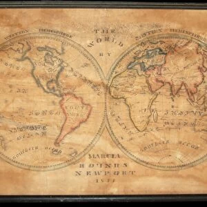
Fine Art Print : The World in Hemispheres, 1902. Creator: Unknown


![]()
Fine Art Prints From Heritage Images
The World in Hemispheres, 1902. Creator: Unknown
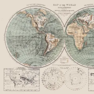
The World in Hemispheres, 1902. Eastern and Western Hemispheres, and below, comparative view of the principal mountains with heights in feet. From The Century Atlas of the World. [John Walker & Co, Ltd. London, 1902]
Heritage Images features heritage image collections
Media ID 15512294
© The Print Collector / Heritage-Images
Eastern Edinburgh Geographical Institute Western World Hemisphere
20"x16" (+3" Border) Fine Art Print
Discover the fascinating world of yesteryears with our exquisite fine art print from Media Storehouse. This captivating image, titled "The World in Hemispheres, 1902," showcases an intriguing representation of the Earth's Eastern and Western Hemispheres. The print also includes a comparative view of the principal mountains with their heights in feet. This vintage map, sourced from Heritage Images and created in 1902, adds an elegant touch to any room and is a perfect conversation starter. Delve into the rich history of cartography and geography with this unique piece from Media Storehouse's Fine Art Prints collection.
20x16 image printed on 26x22 Fine Art Rag Paper with 3" (76mm) white border. Our Fine Art Prints are printed on 300gsm 100% acid free, PH neutral paper with archival properties. This printing method is used by museums and art collections to exhibit photographs and art reproductions.
Our fine art prints are high-quality prints made using a paper called Photo Rag. This 100% cotton rag fibre paper is known for its exceptional image sharpness, rich colors, and high level of detail, making it a popular choice for professional photographers and artists. Photo rag paper is our clear recommendation for a fine art paper print. If you can afford to spend more on a higher quality paper, then Photo Rag is our clear recommendation for a fine art paper print.
Estimated Image Size (if not cropped) is 50.8cm x 35.4cm (20" x 13.9")
Estimated Product Size is 66cm x 55.9cm (26" x 22")
These are individually made so all sizes are approximate
Artwork printed orientated as per the preview above, with landscape (horizontal) orientation to match the source image.
FEATURES IN THESE COLLECTIONS
> Europe
> United Kingdom
> Scotland
> Edinburgh
> Edinburgh
> Europe
> United Kingdom
> Scotland
> Lothian
> Edinburgh
> Maps and Charts
> Related Images
> Maps and Charts
> World
EDITORS COMMENTS
This print showcases "The World in Hemispheres, 1902" a remarkable creation by an unknown artist. The image is derived from "The Century Atlas of the World" published by John Walker & Co in London during the early 20th century. In this colorful and detailed map, both the Eastern and Western Hemispheres are depicted, providing a comprehensive view of our planet's geography. What makes this print truly fascinating is its inclusion of a comparative view of the principal mountains with their heights measured in feet. This additional feature allows viewers to appreciate the grandeur and scale of these majestic natural formations across different regions. The craftsmanship exhibited in this piece highlights not only the cartographic expertise but also an artistic flair that captures attention. Every contour, line, and color choice serves to convey essential geographical information while creating an aesthetically pleasing composition. As we gaze upon this historical artifact, it reminds us of how far we have come in understanding our world's vastness and diversity. It invites contemplation on how explorers once relied on maps like these to navigate uncharted territories or plan daring expeditions. "The World in Hemispheres, 1902" stands as a testament to human curiosity about our planet's wonders and serves as a reminder that even though created over a century ago by an unknown hand, its beauty continues to captivate audiences today.
MADE IN THE USA
Safe Shipping with 30 Day Money Back Guarantee
FREE PERSONALISATION*
We are proud to offer a range of customisation features including Personalised Captions, Color Filters and Picture Zoom Tools
SECURE PAYMENTS
We happily accept a wide range of payment options so you can pay for the things you need in the way that is most convenient for you
* Options may vary by product and licensing agreement. Zoomed Pictures can be adjusted in the Basket.