Fine Art Print > Europe > France > Paris > Maps
Fine Art Print : Map of the Paris Universal Exposition, 1900


![]()
Fine Art Prints from Heritage Images
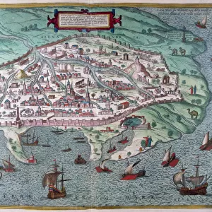
Map of the Paris Universal Exposition, 1900
Map of the Paris Universal Exposition, 1900. More than 50 million people attended the exposition, designed to celebrate the achievements of the 19th century and anticipate the advances that would be made in the 20th
Heritage Images features heritage image collections
Media ID 14873572
© Artmedia / Heritage-Images
Attraction Cartography Cultural Event Map Making Paris Exposition 1900 Print Collector3
20"x16" (+3" Border) Fine Art Print
Step back in time with our exquisite fine art print of the Map of the Paris Universal Exposition, 1900. This stunning piece, brought to you by Media Storehouse in collaboration with Heritage Images, transports you to the bustling event that drew over 50 million visitors. Celebrating the achievements of the 19th century, this map is a captivating testament to a bygone era. Add an air of sophistication and historical charm to your space with this beautiful fine art print.
20x16 image printed on 26x22 Fine Art Rag Paper with 3" (76mm) white border. Our Fine Art Prints are printed on 300gsm 100% acid free, PH neutral paper with archival properties. This printing method is used by museums and art collections to exhibit photographs and art reproductions.
Our fine art prints are high-quality prints made using a paper called Photo Rag. This 100% cotton rag fibre paper is known for its exceptional image sharpness, rich colors, and high level of detail, making it a popular choice for professional photographers and artists. Photo rag paper is our clear recommendation for a fine art paper print. If you can afford to spend more on a higher quality paper, then Photo Rag is our clear recommendation for a fine art paper print.
Estimated Image Size (if not cropped) is 50.8cm x 40.6cm (20" x 16")
Estimated Product Size is 66cm x 55.9cm (26" x 22")
These are individually made so all sizes are approximate
Artwork printed orientated as per the preview above, with landscape (horizontal) orientation to match the source image.
FEATURES IN THESE COLLECTIONS
> Europe
> France
> Paris
> Maps
> Europe
> France
> Paris
> Related Images
> Maps and Charts
> Related Images
EDITORS COMMENTS
This print showcases the "Map of the Paris Universal Exposition, 1900". With its vibrant colors and intricate details, this map takes us back to a significant cultural event that attracted more than 50 million people. The exposition was a grand celebration of the achievements of the 19th century while also offering a glimpse into the anticipated advancements of the 20th century. The map serves as both an artistic representation and a functional guide to navigate through this remarkable event. It highlights various attractions and locations within Paris, emphasizing its importance as the host city for such an extraordinary gathering. As we study this piece, we can't help but marvel at how it captures not only geographical information but also embodies art media and cartography. Created in France during the early years of the 20th century, this print reflects both French culture and their dedication to showcasing innovation on a global scale. The attention to detail in every stroke demonstrates meticulous craftsmanship by skilled map makers who aimed to provide visitors with an immersive experience. As we admire this historical artifact from AccuSoft Inc. , let us appreciate how it encapsulates not just a moment in time but also represents human progress and imagination. This photograph invites us to explore our past while contemplating what lies ahead for future generations.
MADE IN THE USA
Safe Shipping with 30 Day Money Back Guarantee
FREE PERSONALISATION*
We are proud to offer a range of customisation features including Personalised Captions, Color Filters and Picture Zoom Tools
SECURE PAYMENTS
We happily accept a wide range of payment options so you can pay for the things you need in the way that is most convenient for you
* Options may vary by product and licensing agreement. Zoomed Pictures can be adjusted in the Cart.