Fine Art Print > Europe > Germany > Maps
Fine Art Print : Map of the extent of the Hanseatic League in about 1400


![]()
Fine Art Prints from Heritage Images
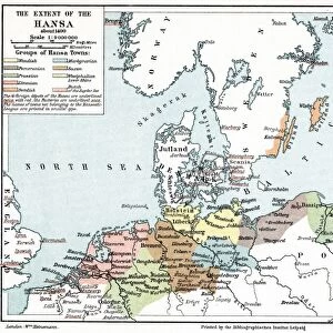
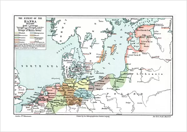
Map of the extent of the Hanseatic League in about 1400
Map of the extent of the Hanseatic League in about 1400. The Hanseatic League was an alliance of about 100 north German towns and trading interests important in northern Europe from the 13th century. At the peak of its influence in the late 14th century the League enjoyed a virtual monopoly of trade in Scandinavia and the Baltic, but its power declined from the 15th century and its last Diet (assembly) met in 1669
Heritage Images features heritage image collections
Media ID 14844630
© Ann Ronan Picture Library / Heritage-Images
Baltic Sea Business Commerce Hanseatic League Merchant Ann Ronan Pictures
21"x14" (+3" Border) Fine Art Print
Discover the rich history of northern Europe with our exquisite Fine Art Print of the Hanseatic League Map from the 15th century. This captivating and intricately detailed print, sourced from Heritage Images, showcases the extent of the Hanseatic League in about 1400 - an alliance of approximately 100 north German towns and trading interests that played a significant role in shaping the economic and political landscape of Europe. Bring history to life in your home or office with this beautiful and authentic work of art.
21x14 image printed on 27x20 Fine Art Rag Paper with 3" (76mm) white border. Our Fine Art Prints are printed on 300gsm 100% acid free, PH neutral paper with archival properties. This printing method is used by museums and art collections to exhibit photographs and art reproductions.
Our fine art prints are high-quality prints made using a paper called Photo Rag. This 100% cotton rag fibre paper is known for its exceptional image sharpness, rich colors, and high level of detail, making it a popular choice for professional photographers and artists. Photo rag paper is our clear recommendation for a fine art paper print. If you can afford to spend more on a higher quality paper, then Photo Rag is our clear recommendation for a fine art paper print.
Estimated Image Size (if not cropped) is 53.3cm x 34.1cm (21" x 13.4")
Estimated Product Size is 68.6cm x 50.8cm (27" x 20")
These are individually made so all sizes are approximate
Artwork printed orientated as per the preview above, with landscape (horizontal) orientation to match the source image.
FEATURES IN THESE COLLECTIONS
> Europe
> Germany
> Related Images
> Europe
> Related Images
> Maps and Charts
> Related Images
EDITORS COMMENTS
This print showcases a detailed map of the extent of the Hanseatic League in approximately 1400. The Hanseatic League, an alliance consisting of around 100 north German towns and trading interests, played a crucial role in shaping northern Europe's economic landscape during the 13th century. At its zenith in the late 14th century, this league held a near monopoly on trade in Scandinavia and the Baltic region. The vibrant colors used to depict this historical map bring to life the extensive reach of the league's influence across various countries and regions. From Germany to Scandinavia, from bustling ports along the Baltic Sea to inland trading hubs, this visual representation highlights how commerce thrived under their governance. However, as time progressed into the 15th century, we witness a decline in power for this once mighty alliance. The last Diet or assembly meeting took place in 1669, marking an end to an era that had shaped economies and politics for centuries. As we delve into this remarkable print by Unknown (creator), it serves as a reminder of how geography played a pivotal role in shaping history. It is through maps like these that we can appreciate not only our past but also gain insights into how trade routes were established and transformed over time within Europe's dynamic commercial landscape.
MADE IN THE USA
Safe Shipping with 30 Day Money Back Guarantee
FREE PERSONALISATION*
We are proud to offer a range of customisation features including Personalised Captions, Color Filters and Picture Zoom Tools
SECURE PAYMENTS
We happily accept a wide range of payment options so you can pay for the things you need in the way that is most convenient for you
* Options may vary by product and licensing agreement. Zoomed Pictures can be adjusted in the Cart.