Fine Art Print > Animals > Mammals > Cats (Domestic) > Turkish Van
Fine Art Print : Map of the border between Russia and Turkey, First World War, (c1920). Creator: Unknown
. Creator: Unknown")

![]()
Fine Art Prints From Heritage Images
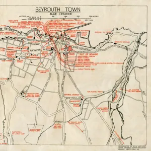
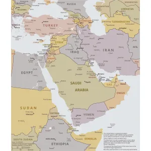
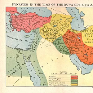
Map of the border between Russia and Turkey, First World War, (c1920). Creator: Unknown
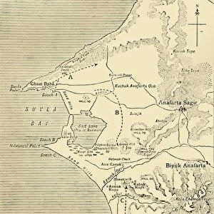
Map of the border between Russia and Turkey, First World War, (c1920). Map illustrating Turkeys disastrous Advance in the Caucasus and her Invasion of Persia - December, 1914 - January, 1915. From " The Great World War - A History" Volume II, edited by Frank A Mumby. [The Gresham Publishing Company Ltd, London, c1920]
Heritage Images features heritage image collections
Media ID 19175253
© The Print Collector/Heritage Images
Advance Al Mawsil Black Sea Border Caucasus Caucasus Asia Central Asia Frank Arthur Frank Arthur Mumby Front Line Frontier Frontline Gresham Publishing Co Ltd Gresham Publishing Company Iran Iraq Keystone Archives Mosul Mumby Mumby Frank Arthur Ninawa Persia Position Positions The Great World War A History Theatre Of War Turkey Turkish Battlefield Lake Van
20"x16" (+3" Border) Fine Art Print
Step back in time with our exclusive Fine Art Print from Media Storehouse, featuring an intriguing and historically significant map. This captivating image, sourced from Heritage Images, depicts the border between Russia and Turkey during the First World War, around 1920. Witness the strategic complexities of the conflict as Turkey's disastrous advance in the Caucasus and invasion of Persia unfolds. The creator and date of the map remain unknown, adding to its allure. Bring history into your home or office with this unique and intriguing piece.
20x16 image printed on 26x22 Fine Art Rag Paper with 3" (76mm) white border. Our Fine Art Prints are printed on 300gsm 100% acid free, PH neutral paper with archival properties. This printing method is used by museums and art collections to exhibit photographs and art reproductions.
Our fine art prints are high-quality prints made using a paper called Photo Rag. This 100% cotton rag fibre paper is known for its exceptional image sharpness, rich colors, and high level of detail, making it a popular choice for professional photographers and artists. Photo rag paper is our clear recommendation for a fine art paper print. If you can afford to spend more on a higher quality paper, then Photo Rag is our clear recommendation for a fine art paper print.
Estimated Image Size (if not cropped) is 40.6cm x 50.8cm (16" x 20")
Estimated Product Size is 55.9cm x 66cm (22" x 26")
These are individually made so all sizes are approximate
Artwork printed orientated as per the preview above, with portrait (vertical) orientation to match the source image.
FEATURES IN THESE COLLECTIONS
> Animals
> Mammals
> Cats (Domestic)
> Turkish Van
> Asia
> Iran
> Lakes
> Related Images
> Asia
> Iran
> Related Images
> Asia
> Iraq
> Related Images
> Asia
> Turkey
> Lakes
> Lake Van
> Asia
> Turkey
> Lakes
> Related Images
> Asia
> Turkey
> Related Images
EDITORS COMMENTS
This print showcases a historic map of the border between Russia and Turkey during the First World War, dating back to around 1920. The creator remains unknown, adding an air of mystery to this intriguing piece. The map itself serves as a visual representation of Turkey's ill-fated advance in the Caucasus region and its subsequent invasion of Persia between December 1914 and January 1915. Originally featured in "The Great World War - A History". Volume II, edited by Frank A Mumby, this print offers a glimpse into the geopolitical landscape of that era. It highlights key geographical features such as Lake Van and Mosul Ninawa in Iraq, while also illustrating the strategic positions held by both Russian and Turkish forces along the border. As we delve into this historical artifact, it becomes evident that it not only depicts a specific moment in time but also symbolizes the larger context of warfare during World War I. This image transports us back to an era when nations were locked in conflict over territorial disputes and power struggles across Central Asia. Preserved by The Print Collector from Keystone Archives, this photograph reminds us of how maps can serve as powerful tools for understanding history. It invites viewers to reflect on the consequences faced by countries involved in war while appreciating their efforts to navigate complex landscapes amidst chaos.
MADE IN THE USA
Safe Shipping with 30 Day Money Back Guarantee
FREE PERSONALISATION*
We are proud to offer a range of customisation features including Personalised Captions, Color Filters and Picture Zoom Tools
SECURE PAYMENTS
We happily accept a wide range of payment options so you can pay for the things you need in the way that is most convenient for you
* Options may vary by product and licensing agreement. Zoomed Pictures can be adjusted in the Basket.