Fine Art Print > Europe > United Kingdom > England > London > Art > Theatre
Fine Art Print : The Battles of the Flanders Ridges, July 30-November 26, 1917, (c1920). Creator: Unknown
. Creator: Unknown")

![]()
Fine Art Prints From Heritage Images
The Battles of the Flanders Ridges, July 30-November 26, 1917, (c1920). Creator: Unknown
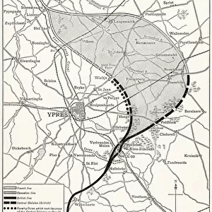
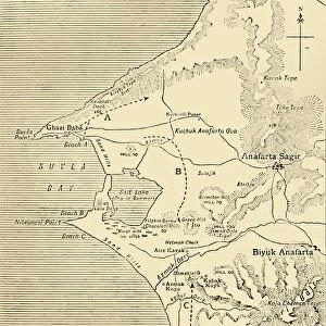
The Battles of the Flanders Ridges, July 30-November 26, 1917, (c1920)....map illustrating successive stages of the Allies advance...inset, key map showing the Flanders Front and the seaward end of the Allies lines on July 30, 1917. The Third Battle of Ypres, also known as the Battle of Passchendaele, took place on the Belgian Western Front from July to November 1917. It was fought between the British, Belgian and French armies against the Germans, and resulted in the deaths of hundreds of thousands of men. From " The Great World War: A History", Volume VII, edited by Frank A Mumby. [The Gresham Publishing Company Ltd, London, c1920]
Heritage Images features heritage image collections
Media ID 19665955
© The Print Collector/Heritage Images
Advance Allies Battle Of Passchendaele Frank A Frank A Mumby Frank Arthur Frank Arthur Mumby Front Line Frontline Gresham Publishing Co Ltd Gresham Publishing Company Keystone Archives Lines Mumby Mumby Frank A Mumby Frank Arthur Position Positions Ridge The Great World War A History Theatre Of War Third Battle Of Ypres Western Front Ypres Ypres Flanders Belgium Battlefield
20"x16" (+3" Border) Fine Art Print
Step back in time with this captivating Fine Art Print from Media Storehouse's historical collection. This vintage map, dating back to the early 1920s, illustrates the pivotal Battles of the Flanders Ridges, fought between July 30 and November 26, 1917, during World War I. The intricately detailed illustration showcases the successive stages of the Allies' advance, providing a unique perspective into the strategic maneuvers and battles that shaped the course of the war. With its rich history and timeless appeal, this Unknown creation from Heritage Images is a must-have for history enthusiasts and art collectors alike.
20x16 image printed on 26x22 Fine Art Rag Paper with 3" (76mm) white border. Our Fine Art Prints are printed on 300gsm 100% acid free, PH neutral paper with archival properties. This printing method is used by museums and art collections to exhibit photographs and art reproductions.
Our fine art prints are high-quality prints made using a paper called Photo Rag. This 100% cotton rag fibre paper is known for its exceptional image sharpness, rich colors, and high level of detail, making it a popular choice for professional photographers and artists. Photo rag paper is our clear recommendation for a fine art paper print. If you can afford to spend more on a higher quality paper, then Photo Rag is our clear recommendation for a fine art paper print.
Estimated Image Size (if not cropped) is 40.6cm x 50.8cm (16" x 20")
Estimated Product Size is 55.9cm x 66cm (22" x 26")
These are individually made so all sizes are approximate
Artwork printed orientated as per the preview above, with portrait (vertical) orientation to match the source image.
FEATURES IN THESE COLLECTIONS
> Europe
> Belgium
> Related Images
> Europe
> France
> Canton
> Allier
> Europe
> United Kingdom
> England
> London
> Art
> Theatre
> Historic
> Battles
> Related Images
> Historic
> World War I and II
EDITORS COMMENTS
This print titled "The Battles of the Flanders Ridges, July 30-November 26,1917" takes us back to the tumultuous era of the First World War. Created by an unknown artist around 1920, this map illustrates the successive stages of the Allies' advance during one of the most significant battles in history. Known as The Third Battle of Ypres or The Battle of Passchendaele, this fierce conflict unfolded on the Belgian Western Front from July to November 1917. It witnessed a relentless struggle between British, Belgian, and French forces against their German adversaries. Tragically, countless lives were lost during these months. Featured as an inset within this historical map is a key that highlights both the Flanders Front and the seaward end of the Allies' lines on July 30th, 1917. This visual aid provides valuable context for understanding how military positions evolved throughout this protracted battle. Taken from Volume VII of "The Great World War: A History" edited by Frank A Mumby and published by The Gresham Publishing Company Ltd in London circa 1920; this print offers a glimpse into one chapter among many in humanity's shared past. It serves as a poignant reminder not only of our capacity for destruction but also our resilience and determination amidst unimaginable adversity.
MADE IN THE USA
Safe Shipping with 30 Day Money Back Guarantee
FREE PERSONALISATION*
We are proud to offer a range of customisation features including Personalised Captions, Color Filters and Picture Zoom Tools
SECURE PAYMENTS
We happily accept a wide range of payment options so you can pay for the things you need in the way that is most convenient for you
* Options may vary by product and licensing agreement. Zoomed Pictures can be adjusted in the Basket.