Fine Art Print > Africa > South Africa > Maps
Fine Art Print : Afrique Anglaise, Sud- Ouest Africain; Afrique Australe, 1914. Creator: Unknown


![]()
Fine Art Prints from Heritage Images
Afrique Anglaise, Sud- Ouest Africain; Afrique Australe, 1914. Creator: Unknown
Afrique Anglaise, Sud- Ouest Africain; Afrique Australe, 1914. From "Grande Geographie Bong Illustree", 1914
Heritage Images features heritage image collections
Media ID 36296431
© The Print Collector/Heritage Images
Cartography Geological Map Map Making Mapmaking South Africa British Empire
20"x16" (+3" Border) Fine Art Print
Step into the past with our exquisite selection of Fine Art Prints from Media Storehouse. This captivating vintage image, titled "Afrique Anglaise, Sud-Ouest Africain; Afrique Australe," dates back to 1914. Originally published in the Grande Geographie Bong Illustree, this stunning piece showcases an intriguing depiction of Africa during the early 20th century. With its rich colors and intricate details, this print is not only a beautiful addition to your home or office décor but also a fascinating glimpse into history. Unknown origins only add to the allure of this mysterious and enchanting piece. Experience the charm of the past with our Fine Art Prints from Media Storehouse.
20x16 image printed on 26x22 Fine Art Rag Paper with 3" (76mm) white border. Our Fine Art Prints are printed on 300gsm 100% acid free, PH neutral paper with archival properties. This printing method is used by museums and art collections to exhibit photographs and art reproductions.
Our fine art prints are high-quality prints made using a paper called Photo Rag. This 100% cotton rag fibre paper is known for its exceptional image sharpness, rich colors, and high level of detail, making it a popular choice for professional photographers and artists. Photo rag paper is our clear recommendation for a fine art paper print. If you can afford to spend more on a higher quality paper, then Photo Rag is our clear recommendation for a fine art paper print.
Estimated Image Size (if not cropped) is 40.6cm x 50.8cm (16" x 20")
Estimated Product Size is 55.9cm x 66cm (22" x 26")
These are individually made so all sizes are approximate
Artwork printed orientated as per the preview above, with portrait (vertical) orientation to match the source image.
FEATURES IN THESE COLLECTIONS
> Africa
> South Africa
> Maps
> Africa
> South Africa
> Related Images
> Maps and Charts
> British Empire Maps
> Maps and Charts
> Geological Map
> Maps and Charts
> Related Images
EDITORS COMMENTS
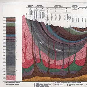
This map print, titled "Afrique Anglaise, Sud-Ouest Africain; Afrique Australe" from the 1914 edition of "Grande Geographie Bong Illustree," provides a fascinating glimpse into the geographical knowledge and colonial ambitions of Europe during the early 20th century. The map, created by an unknown cartographer, meticulously delineates the African continent as it was then understood, with a focus on the British and French colonial holdings in Africa. The map's rich colors and intricate detail reflect the height of mapmaking artistry during this period. The red and blue hues denote the territories under British and French control, respectively, while the beige and brown tones represent the unexplored or unclaimed regions. The map also includes annotations in French and German, reflecting the multilingual nature of European colonialism. The map's title translates to "English Africa, South-West Africa; Southern Africa," indicating the primary focus on the territories that would later become known as South Africa and Namibia. The map's geological features are also depicted, including mountains, rivers, and bodies of water, providing a comprehensive view of the physical landscape of the continent. This map serves as a powerful reminder of the colonial era and the profound impact it had on the world. It is a testament to the human desire to explore, chart, and claim new territories, and to the complex web of political and cultural relationships that emerged as a result. The map's unknown creator remains a mystery, but their work continues to shed light on a pivotal moment in history.
MADE IN THE USA
Safe Shipping with 30 Day Money Back Guarantee
FREE PERSONALISATION*
We are proud to offer a range of customisation features including Personalised Captions, Color Filters and Picture Zoom Tools
SECURE PAYMENTS
We happily accept a wide range of payment options so you can pay for the things you need in the way that is most convenient for you
* Options may vary by product and licensing agreement. Zoomed Pictures can be adjusted in the Cart.