Fine Art Print > Arts > Landscape paintings > Waterfall and river artworks > River artworks
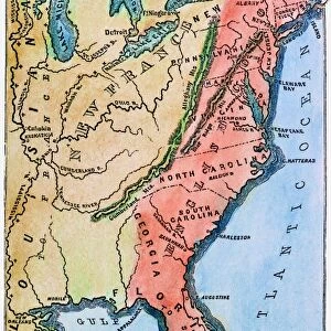
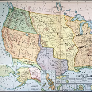
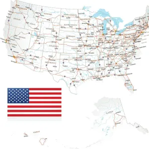
Fine Art Print : MAP: UNITED STATES, 1905. Map of the continental United States (excluding Alaska), 1905
, 1905")

![]()
Fine Art Prints From Granger
MAP: UNITED STATES, 1905. Map of the continental United States (excluding Alaska), 1905
Granger holds millions of images spanning more than 25,000 years of world history, from before the Stone Age to the dawn of the Space Age
Media ID 6617459
20"x16" (+3" Border) Fine Art Print
Discover history through the lens of a bygone era with our exquisite selection of Fine Art Prints from Media Storehouse. This captivating print showcases a detailed map of the United States from 1905, created by The Granger Collection. Travel back in time as you explore the continental United States, excluding Alaska, as it appeared over a century ago. Each print is meticulously reproduced from original sources, ensuring the highest quality and authenticity. Bring a piece of history into your home or office and ignite conversations with this stunning and intriguing addition to your decor.
20x16 image printed on 26x22 Fine Art Rag Paper with 3" (76mm) white border. Our Fine Art Prints are printed on 300gsm 100% acid free, PH neutral paper with archival properties. This printing method is used by museums and art collections to exhibit photographs and art reproductions.
Our fine art prints are high-quality prints made using a paper called Photo Rag. This 100% cotton rag fibre paper is known for its exceptional image sharpness, rich colors, and high level of detail, making it a popular choice for professional photographers and artists. Photo rag paper is our clear recommendation for a fine art paper print. If you can afford to spend more on a higher quality paper, then Photo Rag is our clear recommendation for a fine art paper print.
Estimated Image Size (if not cropped) is 50.8cm x 36.7cm (20" x 14.4")
Estimated Product Size is 66cm x 55.9cm (26" x 22")
These are individually made so all sizes are approximate
Artwork printed orientated as per the preview above, with landscape (horizontal) orientation to match the source image.
FEATURES IN THESE COLLECTIONS
> Arts
> Landscape paintings
> Waterfall and river artworks
> River artworks
> Maps and Charts
> Early Maps
> Maps and Charts
> Related Images
> Granger Art on Demand
> Maps
MAP - UNITED STATES, 1905. A captivating snapshot of America's early landscape
EDITORS COMMENTS
. This stunning print showcases a meticulously detailed map of the continental United States in the year 1905. With its rich historical significance and intricate cartographic design, this artwork from Granger Art on Demand offers a glimpse into the past and allows us to explore America's vast territories during that era. The map encompasses all states except Alaska, presenting an accurate representation of the country's geography at that time. It highlights major cities, rivers, mountain ranges, and other significant landmarks that shaped the nation's identity. The attention to detail is remarkable; every contour and boundary has been carefully etched onto this vintage piece. Transporting us back over a century ago, this photograph evokes nostalgia for an era when America was still developing its identity as a global power. It serves as a visual testament to our nation's growth and progress throughout history. Whether you are an avid historian or simply fascinated by maps and their ability to tell stories about our world, this print will undoubtedly captivate your imagination. Display it proudly in your home or office space as both an educational tool and a conversation starter – sparking discussions about American history or igniting wanderlust for those who long to traverse these lands. Granger Art on Demand presents yet another timeless masterpiece with "MAP: UNITED STATES, 1905" allowing us to appreciate the beauty of cartography while celebrating our shared heritage as Americans.
MADE IN THE USA
Safe Shipping with 30 Day Money Back Guarantee
FREE PERSONALISATION*
We are proud to offer a range of customisation features including Personalised Captions, Color Filters and Picture Zoom Tools
SECURE PAYMENTS
We happily accept a wide range of payment options so you can pay for the things you need in the way that is most convenient for you
* Options may vary by product and licensing agreement. Zoomed Pictures can be adjusted in the Basket.