Fine Art Print > Arts > Artists > A > Peter Apian
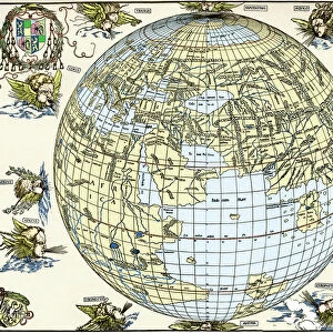
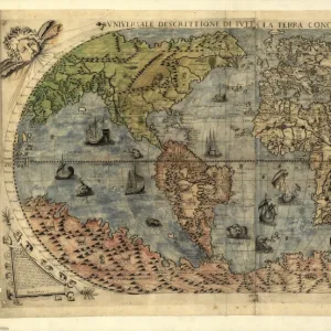
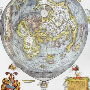
Fine Art Print : APIAN: WORLD MAP, 1530. Heart-shaped map of the world, with small portraits of Amerigo Vespucci


![]()
Fine Art Prints From Granger
APIAN: WORLD MAP, 1530. Heart-shaped map of the world, with small portraits of Amerigo Vespucci
APIAN: WORLD MAP, 1530. Heart-shaped map of the world, with small portraits of Amerigo Vespucci (upper left) and Ptolemy (upper right) by Peter Apian, 1530
Granger holds millions of images spanning more than 25,000 years of world history, from before the Stone Age to the dawn of the Space Age
Media ID 6622297
1530 Amerigo Cartouche Claudius Globe Heart Pieter Ptolemaic Ptolemy Vespucci World Apian
20"x16" (+3" Border) Fine Art Print
Discover the captivating history of cartography with our Fine Art Print of APIAN: WORLD MAP, 1530. This exquisite piece, created by renowned mapmaker Peter Apian, showcases a heart-shaped world map adorned with small portraits of Amerigo Vespucci and Ptolemy. A testament to the exploration and discovery of the New World, this stunning print is a must-have for history enthusiasts, cartographers, and art collectors alike. Bring a piece of the past into your home or office with our high-quality Fine Art Print of APIAN: WORLD MAP, 1530.
20x16 image printed on 26x22 Fine Art Rag Paper with 3" (76mm) white border. Our Fine Art Prints are printed on 300gsm 100% acid free, PH neutral paper with archival properties. This printing method is used by museums and art collections to exhibit photographs and art reproductions.
Our fine art prints are high-quality prints made using a paper called Photo Rag. This 100% cotton rag fibre paper is known for its exceptional image sharpness, rich colors, and high level of detail, making it a popular choice for professional photographers and artists. Photo rag paper is our clear recommendation for a fine art paper print. If you can afford to spend more on a higher quality paper, then Photo Rag is our clear recommendation for a fine art paper print.
Estimated Image Size (if not cropped) is 36.2cm x 50.8cm (14.3" x 20")
Estimated Product Size is 55.9cm x 66cm (22" x 26")
These are individually made so all sizes are approximate
Artwork printed orientated as per the preview above, with portrait (vertical) orientation to match the source image.
FEATURES IN THESE COLLECTIONS
> Arts
> Art Movements
> Renaissance Art
> Arts
> Artists
> A
> Peter Apian
> Arts
> Landscape paintings
> Waterfall and river artworks
> River artworks
> Arts
> Street art graffiti
> Portraits
> Fine art
> Historic
> Renaissance art
> Portraits in renaissance art
> Maps and Charts
> Early Maps
> Maps and Charts
> Related Images
> Maps and Charts
> World
> Granger Art on Demand
> Astronomy
> Granger Art on Demand
> Maps
EDITORS COMMENTS
This print showcases the remarkable "APIAN: WORLD MAP, 1530". Crafted by Peter Apian during the Renaissance period, this heart-shaped map of the world is a true masterpiece. The intricate details and artistic finesse are evident in every corner of this stunning creation. The focal point of the map lies within its heart shape, symbolizing love for exploration and discovery. Surrounding this central motif are small portraits of two influential figures - Amerigo Vespucci on the upper left and Ptolemy on the upper right. These individuals played pivotal roles in shaping our understanding of geography and navigation during that era. As you delve deeper into this artwork, you'll notice various elements that make it truly exceptional. From Claudius Ptolemy's influence on cartography to Pieter Apian's meticulous craftsmanship, every aspect reflects their dedication to accuracy and beauty. The inclusion of a river flowing through the heart further emphasizes humanity's connection with nature and exploration. This detail adds an element of movement and life to an otherwise static representation. Whether you're a history enthusiast or simply appreciate fine art, this print will undoubtedly captivate your imagination. It serves as a reminder of our ancestors' thirst for knowledge about our vast world while also showcasing their artistic prowess.
MADE IN THE USA
Safe Shipping with 30 Day Money Back Guarantee
FREE PERSONALISATION*
We are proud to offer a range of customisation features including Personalised Captions, Color Filters and Picture Zoom Tools
SECURE PAYMENTS
We happily accept a wide range of payment options so you can pay for the things you need in the way that is most convenient for you
* Options may vary by product and licensing agreement. Zoomed Pictures can be adjusted in the Basket.