Fine Art Print > North America > United States of America > Maps
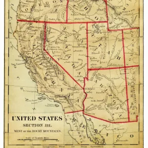
Fine Art Print : USA Western states map 1898


![]()
Fine Art Prints From Fine Art Storehouse
USA Western states map 1898
Map from Physical Geography by R. S. Tarr - The MacMillan Company - London 1898
Unleash your creativity and transform your space into a visual masterpiece!
THEPALMER
Media ID 20773173
© A 2014 Roberto Adrian Photography
20"x16" (+3" Border) Fine Art Print
Step back in time with our exquisite fine art print from The Media Storehouse's collection. This stunning piece showcases a vintage USA Western states map from the year 1898, originally published in "Physical Geography" by R.S. Tarr, The MacMillan Company, London. The intricate details of the map, from the meticulously drawn borders to the carefully labeled territories, transport you back to an era of exploration and discovery. Add this beautiful work of art to your home or office to infuse it with a sense of history and timeless charm.
20x16 image printed on 26x22 Fine Art Rag Paper with 3" (76mm) white border. Our Fine Art Prints are printed on 300gsm 100% acid free, PH neutral paper with archival properties. This printing method is used by museums and art collections to exhibit photographs and art reproductions.
Our fine art prints are high-quality prints made using a paper called Photo Rag. This 100% cotton rag fibre paper is known for its exceptional image sharpness, rich colors, and high level of detail, making it a popular choice for professional photographers and artists. Photo rag paper is our clear recommendation for a fine art paper print. If you can afford to spend more on a higher quality paper, then Photo Rag is our clear recommendation for a fine art paper print.
Estimated Image Size (if not cropped) is 36.3cm x 50.8cm (14.3" x 20")
Estimated Product Size is 55.9cm x 66cm (22" x 26")
These are individually made so all sizes are approximate
Artwork printed orientated as per the preview above, with portrait (vertical) orientation to match the source image.
FEATURES IN THESE COLLECTIONS
> Maps and Charts
> Related Images
> North America
> United States of America
> Maps
EDITORS COMMENTS
This print takes us back in time to the year 1898, when the vast and unexplored landscapes of the western United States were still a mystery waiting to be unraveled. The map featured in this image is an exquisite piece from "Physical Geography" by R. S. Tarr, published by The MacMillan Company in London. As we gaze upon this vintage treasure, our eyes are drawn to the intricate details that adorn each state within the Western region of America. From California's golden shores to Arizona's arid deserts, and from Oregon's lush forests to Nevada's rugged mountains, every contour and boundary comes alive with historical significance. The craftsmanship captured here transports us into an era where cartography was both artistry and science combined. It reminds us of a time when explorers ventured into these untamed territories armed only with their curiosity and determination. "The Palmer" known for curating exceptional pieces at Fine Art Storehouse, has preserved this remarkable snapshot of history for all enthusiasts to appreciate. This particular print serves as a testament not only to the beauty of early cartographic works but also as a reminder of how far we have come since those pioneering days. Whether you are an avid historian or simply captivated by the allure of yesteryears, this photograph invites you on a journey through time - one that will leave you marveling at the vastness and diversity that define America's Western states even today.
MADE IN THE USA
Safe Shipping with 30 Day Money Back Guarantee
FREE PERSONALISATION*
We are proud to offer a range of customisation features including Personalised Captions, Color Filters and Picture Zoom Tools
SECURE PAYMENTS
We happily accept a wide range of payment options so you can pay for the things you need in the way that is most convenient for you
* Options may vary by product and licensing agreement. Zoomed Pictures can be adjusted in the Basket.