Fine Art Print > Arts > Street art graffiti > Digital art > Vector illustrations
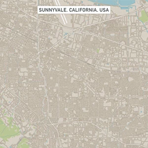
Fine Art Print : San Mateo California US City Street Map


![]()
Fine Art Prints from Fine Art Storehouse
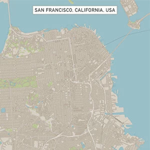
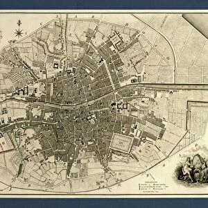
San Mateo California US City Street Map
Vector Illustration of a City Street Map of San Mateo, California, USA. Scale 1:60, 000.
All source data is in the public domain.
U.S. Geological Survey, US Topo
Used Layers:
USGS The National Map: National Hydrography Dataset (NHD)
USGS The National Map: National Transportation Dataset (NTD)
Unleash your creativity and transform your space into a visual masterpiece!
Frank Ramspott
Media ID 15055045
© Frank Ramspott, all rights reserved
Aerial View California City Map Computer Graphic Directly Above Downtown District Gray Road Map Text Digitally Generated Image Green Color San Mateo Silicon Valley White Color
20"x20" (+3" Border) Fine Art Print
Discover the charm of San Mateo, California, with this exquisite city map fine art print from Media Storehouse. Created by renowned artist Frank Ramspott, this vector illustration captures the essence of the US city with intricate detail and precision. With a scale of 1:60,000 and all source data in the public domain, this fine art print is not only an accurate representation but also a beautiful addition to any home or office space. Bring a piece of San Mateo's history and culture into your world with this stunning, high-quality print.
20x20 image printed on 26x26 Fine Art Rag Paper with 3" (76mm) white border. Our Fine Art Prints are printed on 300gsm 100% acid free, PH neutral paper with archival properties. This printing method is used by museums and art collections to exhibit photographs and art reproductions.
Our fine art prints are high-quality prints made using a paper called Photo Rag. This 100% cotton rag fibre paper is known for its exceptional image sharpness, rich colors, and high level of detail, making it a popular choice for professional photographers and artists. Photo rag paper is our clear recommendation for a fine art paper print. If you can afford to spend more on a higher quality paper, then Photo Rag is our clear recommendation for a fine art paper print.
Estimated Image Size (if not cropped) is 50.8cm x 50.8cm (20" x 20")
Estimated Product Size is 66cm x 66cm (26" x 26")
These are individually made so all sizes are approximate
Artwork printed orientated as per the preview above, with landscape (horizontal) or portrait (vertical) orientation to match the source image.
FEATURES IN THESE COLLECTIONS
> Aerial Photography
> Related Images
> Animals
> Insects
> Hemiptera
> Green Scale
> Animals
> Mammals
> Cricetidae
> California Mouse
> Arts
> Contemporary art
> Digital artwork
> Street art
> Arts
> Landscape paintings
> Waterfall and river artworks
> River artworks
> Arts
> Portraits
> Pop art gallery
> Street art portraits
> Arts
> Street art graffiti
> Digital art
> Digital paintings
> Arts
> Street art graffiti
> Digital art
> Vector illustrations
> Maps and Charts
> Geological Map
> Maps and Charts
> Related Images
> Fine Art Storehouse
> Map
> Street Maps
> Fine Art Storehouse
> Map
> USA Maps
EDITORS COMMENTS
This print showcases a meticulously detailed city street map of San Mateo, California, USA. Created with precision and accuracy, this vector illustration offers a comprehensive view of the bustling city nestled in the heart of Silicon Valley. With a scale of 1:60,000, every road, district, and landmark is clearly depicted. The source data used to create this masterpiece is in the public domain and originates from the U. S. Geological Survey's National Map. The National Hydrography Dataset (NHD) provides accurate information about rivers and lakes while the National Transportation Dataset (NTD) ensures an up-to-date representation of streets and transportation routes. In this digitally generated image, we are presented with an aerial view directly above San Mateo's downtown district. The vibrant colors of gray, green, blue, and white bring life to this cartographic marvel. This visually appealing design serves as both a functional tool for navigation as well as an artistic piece that can adorn any wall. With no people present in the image itself but accompanied by informative text detailing its features and origins; it is evident that Frank Ramspott has skillfully crafted this map to showcase not only the physical geography but also his expertise in computer graphics.
MADE IN THE USA
Safe Shipping with 30 Day Money Back Guarantee
FREE PERSONALISATION*
We are proud to offer a range of customisation features including Personalised Captions, Color Filters and Picture Zoom Tools
SECURE PAYMENTS
We happily accept a wide range of payment options so you can pay for the things you need in the way that is most convenient for you
* Options may vary by product and licensing agreement. Zoomed Pictures can be adjusted in the Cart.