Fine Art Print > Arts > Artists > S > Syrian Syrian
Fine Art Print : Syria country map


Please select a smaller print size for this image
![]()
Fine Art Prints from Fine Art Storehouse
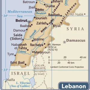
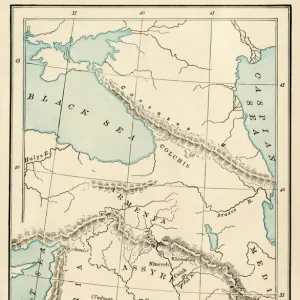
Syria country map
2011 edition
Unleash your creativity and transform your space into a visual masterpiece!
Media ID 14432389
10"x8" (+3" Border) Fine Art Print
20x16 image printed on 26x22 Fine Art Rag Paper with 3" (76mm) white border. Our Fine Art Prints are printed on 300gsm 100% acid free, PH neutral paper with archival properties. This printing method is used by museums and art collections to exhibit photographs and art reproductions.
Our fine art prints are high-quality prints made using a paper called Photo Rag. This 100% cotton rag fibre paper is known for its exceptional image sharpness, rich colors, and high level of detail, making it a popular choice for professional photographers and artists. Photo rag paper is our clear recommendation for a fine art paper print. If you can afford to spend more on a higher quality paper, then Photo Rag is our clear recommendation for a fine art paper print.
Estimated Product Size is 40.6cm x 35.6cm (16" x 14")
These are individually made so all sizes are approximate
Artwork printed orientated as per the preview above, with landscape (horizontal) orientation to match the source image.
FEATURES IN THESE COLLECTIONS
> Arts
> Artists
> S
> Syrian Syrian
> Asia
> Syria
> Related Images
> Maps and Charts
> Related Images
> Fine Art Storehouse
> Map
> Reference Maps
EDITORS COMMENTS
This print showcases the Syria country map from the 2011 edition, capturing a moment in time when the nation was on the brink of significant change. The intricate details and vibrant colors of this artwork make it an exquisite addition to any collection. The map itself serves as a powerful reminder of Syria's rich history and cultural heritage. It highlights major cities, towns, rivers, and mountain ranges that have shaped its landscape for centuries. Each line tells a story of ancient civilizations, conquerors, and diverse communities that have called this land home. However, beyond its geographical significance lies a deeper narrative within this image. The year 2011 marked the beginning of a tumultuous period for Syria—a turning point that would forever alter its trajectory. This photograph encapsulates both hope and uncertainty as it freezes time just before conflict erupted across the nation. As we gaze upon this mesmerizing artwork, we are reminded not only of Syria's beauty but also of its resilience in times of adversity. It prompts us to reflect on how maps can serve as more than just navigational tools; they can be windows into complex histories and catalysts for dialogue about our shared humanity. With every glance at this remarkable piece from Fine Art Storehouse, we are transported to another world—one filled with stories waiting to be told and lessons waiting to be learned.
MADE IN THE USA
Safe Shipping with 30 Day Money Back Guarantee
FREE PERSONALISATION*
We are proud to offer a range of customisation features including Personalised Captions, Color Filters and Picture Zoom Tools
SECURE PAYMENTS
We happily accept a wide range of payment options so you can pay for the things you need in the way that is most convenient for you
* Options may vary by product and licensing agreement. Zoomed Pictures can be adjusted in the Cart.