Fine Art Print > Europe > United Kingdom > Wales > Pembrokeshire > Pembroke
Fine Art Print : MA Plymouth Pembroke Vector Road Map

![]()
Fine Art Prints from Fine Art Storehouse
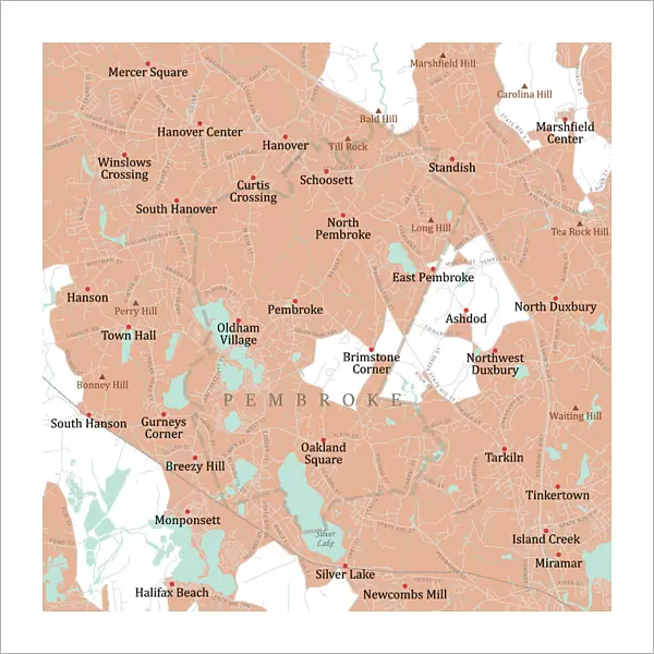
MA Plymouth Pembroke Vector Road Map
MA Plymouth Pembroke Vector Road Map. All source data is in the public domain. U.S. Census Bureau Census Tiger. Used Layers: areawater, linearwater, roads, rails, cousub, pointlm, uac10
Unleash your creativity and transform your space into a visual masterpiece!
Frank Ramspott
Media ID 20692693
© Frank Ramspott, all rights reserved
City Map Computer Graphic County Digital Composite District Geographical Border Massachusetts Plymouth Road Map Text Vector Digitally Generated Image Duxbury Hanson Marshfield Pembroke Silver Lake
20"x20" (+3" Border) Fine Art Print
Discover the unique fusion of art and cartography with our MA Plymouth Pembroke Vector Road Map by Frank Ramspott from the Fine Art Storehouse collection. This exquisite fine art print transforms the familiar into the extraordinary, as public domain data from the U.S. Census Bureau Census Tiger is meticulously rendered in vibrant color and intricate detail. Each line, point, and shape is a testament to the beauty and complexity of urban planning, inviting you to explore the rich history and character of Plymouth, Massachusetts. Bring a piece of this captivating visual narrative into your home or office and ignite conversations with its distinctive, visually stunning design.
20x20 image printed on 26x26 Fine Art Rag Paper with 3" (76mm) white border. Our Fine Art Prints are printed on 300gsm 100% acid free, PH neutral paper with archival properties. This printing method is used by museums and art collections to exhibit photographs and art reproductions.
Our fine art prints are high-quality prints made using a paper called Photo Rag. This 100% cotton rag fibre paper is known for its exceptional image sharpness, rich colors, and high level of detail, making it a popular choice for professional photographers and artists. Photo rag paper is our clear recommendation for a fine art paper print. If you can afford to spend more on a higher quality paper, then Photo Rag is our clear recommendation for a fine art paper print.
Estimated Image Size (if not cropped) is 50.8cm x 50.8cm (20" x 20")
Estimated Product Size is 66cm x 66cm (26" x 26")
These are individually made so all sizes are approximate
Artwork printed orientated as per the preview above, with landscape (horizontal) or portrait (vertical) orientation to match the source image.
FEATURES IN THESE COLLECTIONS
> Animals
> Mammals
> Cats (Wild)
> Tiger
> Animals
> Mammals
> Muridae
> Water Mouse
> Arts
> Contemporary art
> Digital artwork
> Street art
> Arts
> Landscape paintings
> Waterfall and river artworks
> River artworks
> Arts
> Portraits
> Pop art gallery
> Street art portraits
> Arts
> Street art graffiti
> Digital art
> Digital paintings
> Europe
> United Kingdom
> Wales
> Pembrokeshire
> Pembroke
> Maps and Charts
> Related Images
> Popular Themes
> Lake District
> Fine Art Storehouse
> Map
> Reference Maps
EDITORS COMMENTS
This print showcases the MA Plymouth Pembroke Vector Road Map, a stunning piece of cartography art. Created by Frank Ramspott, this digitally generated image highlights the intricate details and geographical borders of Massachusetts' Plymouth County district. Utilizing various layers such as areawater, linearwater, roads, rails, cousub, pointlm, and uac10 from publicly available data sources like U. S. Census Bureau Census Tiger, Ramspott has masterfully crafted a visually appealing city map. The vibrant colors and precise vector graphics bring life to this computer-generated composition. The absence of people in the image allows for an unobstructed view of the map's features including rivers, lakes, streets, and text labels that help navigate through cities like Plymouth and Pembroke. Notably featured are landmarks such as Oldham Village and Monponsett alongside natural wonders like Silver Lake. With its meticulous attention to detail and flawless design execution, this print serves as both a functional road map for travelers in Massachusetts as well as an aesthetically pleasing piece of artwork. Whether you're fascinated by physical geography or simply appreciate digital composites that showcase our world's beauty from above - this image is sure to captivate your imagination.
MADE IN THE USA
Safe Shipping with 30 Day Money Back Guarantee
FREE PERSONALISATION*
We are proud to offer a range of customisation features including Personalised Captions, Color Filters and Picture Zoom Tools
SECURE PAYMENTS
We happily accept a wide range of payment options so you can pay for the things you need in the way that is most convenient for you
* Options may vary by product and licensing agreement. Zoomed Pictures can be adjusted in the Cart.