Fine Art Print > Arts > Contemporary art > Digital artwork > Street art
Fine Art Print : CT Litchfield Litchfield Town Vector Road Map


![]()
Fine Art Prints from Fine Art Storehouse
CT Litchfield Litchfield Town Vector Road Map
CT Litchfield Litchfield Town Vector Road Map. All source data is in the public domain. U.S. Census Bureau Census Tiger. Used Layers: areawater, linearwater, roads, rails, cousub, pointlm, uac10
Unleash your creativity and transform your space into a visual masterpiece!
Frank Ramspott
Media ID 20687773
© Frank Ramspott, all rights reserved
Bethlehem City Map Computer Graphic Connecticut County Digital Composite District Geographical Border Litchfield Road Map Sandy Beach Text Vector Village Bantam Digitally Generated Image Milton Mount Prospect Thomaston Torrington Woodville
20"x20" (+3" Border) Fine Art Print
Discover the unique blend of art and cartography with our CT Litchfield Litchfield Town Vector Road Map print from the Media Storehouse Fine Art collection. This stunning piece, created by Frank Ramspott, transforms census data into a captivating work of art. The intricate vector design highlights the roads, waterways, and landmarks of Litchfield Town, CT with an artistic flair. A perfect addition to any home or office space, this fine art print not only serves as a beautiful decorative piece but also as a celebration of the data behind it. All source data is in the public domain and used with permission from the U.S. Census Bureau Census Tiger.
20x20 image printed on 26x26 Fine Art Rag Paper with 3" (76mm) white border. Our Fine Art Prints are printed on 300gsm 100% acid free, PH neutral paper with archival properties. This printing method is used by museums and art collections to exhibit photographs and art reproductions.
Our fine art prints are high-quality prints made using a paper called Photo Rag. This 100% cotton rag fibre paper is known for its exceptional image sharpness, rich colors, and high level of detail, making it a popular choice for professional photographers and artists. Photo rag paper is our clear recommendation for a fine art paper print. If you can afford to spend more on a higher quality paper, then Photo Rag is our clear recommendation for a fine art paper print.
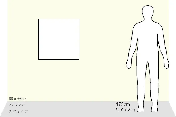
Estimated Image Size (if not cropped) is 50.8cm x 50.8cm (20" x 20")
Estimated Product Size is 66cm x 66cm (26" x 26")
These are individually made so all sizes are approximate
Artwork printed orientated as per the preview above, with landscape (horizontal) or portrait (vertical) orientation to match the source image.
FEATURES IN THESE COLLECTIONS
> Animals
> Mammals
> Cats (Wild)
> Tiger
> Animals
> Mammals
> Muridae
> Water Mouse
> Arts
> Contemporary art
> Digital artwork
> Street art
> Arts
> Landscape paintings
> Waterfall and river artworks
> River artworks
> Arts
> Portraits
> Pop art gallery
> Street art portraits
> Arts
> Street art graffiti
> Digital art
> Digital paintings
> Maps and Charts
> Related Images
> Popular Themes
> Lake District
> Fine Art Storehouse
> Map
> Reference Maps
EDITORS COMMENTS
This print showcases the intricate details of the CT Litchfield Litchfield Town Vector Road Map. Designed and digitally generated by Frank Ramspott, this visually stunning image is a testament to his exceptional cartography skills. With its vibrant colors and precise lines, it effortlessly captures the essence of this picturesque town in Connecticut. The map encompasses various elements that define the region's physical geography, including rivers, lakes, and charming villages like Bantam and Torrington. It also highlights significant landmarks such as Mohawk Mountain and Mount Prospect, adding depth to the overall composition. Through a skillful combination of computer graphics and digital composites, Ramspott has created an aesthetically pleasing city map that is both informative and visually appealing. The inclusion of text ensures easy navigation through the streets while maintaining a clean design. With no people present in the image, all attention is directed towards exploring every corner of this meticulously crafted road map. Each layer used in its creation - from roads to railways - adds another dimension to our understanding of Litchfield Town's layout. As an artwork sourced from public domain data provided by U. S. Census Bureau Census Tiger, this print serves as a beautiful reminder of how art can transform raw information into something truly captivating. Whether displayed in homes or offices, it will undoubtedly spark curiosity about Litchfield Town's unique charm among viewers.
MADE IN THE USA
Safe Shipping with 30 Day Money Back Guarantee
FREE PERSONALISATION*
We are proud to offer a range of customisation features including Personalised Captions, Color Filters and Picture Zoom Tools
SECURE PAYMENTS
We happily accept a wide range of payment options so you can pay for the things you need in the way that is most convenient for you
* Options may vary by product and licensing agreement. Zoomed Pictures can be adjusted in the Cart.