Fine Art Print > Arts > Artists > I > Italian School Italian School
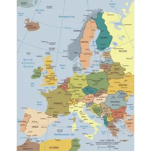
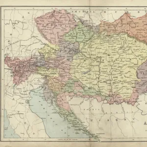
Fine Art Print : Map of Europe 1895


![]()
Fine Art Prints From Fine Art Storehouse
Map of Europe 1895
The Rand-McNally Grammar School Geography 1895 - Chicago & New York
Unleash your creativity and transform your space into a visual masterpiece!
THEPALMER
Media ID 14824619
© This content is subject to copyright
Austria Denmark Norway Portugal Russia Sweden
20"x16" (+3" Border) Fine Art Print
Step back in time with our exquisite Map of Europe 1895 by THEPALMER from the Fine Art Storehouse collection. This vintage fine art print, originally published by Rand-McNally for their Grammar School Geography series in Chicago and New York in 1895, is a captivating piece of historical cartography. With intricate details and authentic antique charm, this print makes a stunning addition to any home or office, transporting you back to an era of exploration and discovery. Bring history to life with this beautiful and authentic fine art print.
20x16 image printed on 26x22 Fine Art Rag Paper with 3" (76mm) white border. Our Fine Art Prints are printed on 300gsm 100% acid free, PH neutral paper with archival properties. This printing method is used by museums and art collections to exhibit photographs and art reproductions.
Our fine art prints are high-quality prints made using a paper called Photo Rag. This 100% cotton rag fibre paper is known for its exceptional image sharpness, rich colors, and high level of detail, making it a popular choice for professional photographers and artists. Photo rag paper is our clear recommendation for a fine art paper print. If you can afford to spend more on a higher quality paper, then Photo Rag is our clear recommendation for a fine art paper print.
Estimated Image Size (if not cropped) is 50.8cm x 40.6cm (20" x 16")
Estimated Product Size is 66cm x 55.9cm (26" x 22")
These are individually made so all sizes are approximate
Artwork printed orientated as per the preview above, with landscape (horizontal) orientation to match the source image.
FEATURES IN THESE COLLECTIONS
> Arts
> Artists
> I
> Italian School Italian School
> Arts
> Artists
> P
> Portuguese School
> Arts
> Artists
> S
> Spanish School
> Europe
> Austria
> Related Images
> Europe
> Denmark
> Related Images
> Fine Art Storehouse
> Map
> Denmark Maps
> Fine Art Storehouse
> Map
> Historical Maps
> Fine Art Storehouse
> Map
> Italian Maps
EDITORS COMMENTS
In this print titled "Map of Europe 1895" we are transported back in time to a bygone era. The map, sourced from the renowned Rand-McNally Grammar School Geography book published in Chicago and New York, offers us a glimpse into the geopolitical landscape of Europe during that period. The intricate details and vibrant colors of the map draw our attention immediately. We can trace our fingers along Portugal's western coast, marvel at Austria's central location, and appreciate Denmark's unique position connecting mainland Europe with Scandinavia. As we explore further, France stands out with its iconic shape while Germany dominates the heart of the continent. Italy beckons us with its distinctive boot-like silhouette as Norway captures our imagination with its rugged fjords. And let us not forget Russia, sprawling across vast territories towards the east. Spain entices us with its sunny allure while Sweden exudes an air of mystery up north. "The Map of Europe 1895" transports us back to a time when borders were different, alliances were shifting, and empires still held sway over vast lands. It serves as a reminder that history is ever-evolving and that understanding our past helps shape our future. This stunning print by THEPALMER showcases not only their artistic talent but also their appreciation for historical artifacts like this vintage map. Its presence on display adds depth and character to any space it graces – be it a study room or an art lover's collection - inviting viewers to embark on a journey through time
MADE IN THE USA
Safe Shipping with 30 Day Money Back Guarantee
FREE PERSONALISATION*
We are proud to offer a range of customisation features including Personalised Captions, Color Filters and Picture Zoom Tools
SECURE PAYMENTS
We happily accept a wide range of payment options so you can pay for the things you need in the way that is most convenient for you
* Options may vary by product and licensing agreement. Zoomed Pictures can be adjusted in the Basket.