Fine Art Print > Oceania > Australia > Maps
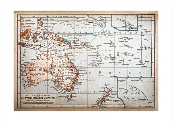
Fine Art Print : Political map of Australia and Polynesia


![]()
Fine Art Prints from Fine Art Storehouse
Political map of Australia and Polynesia
Illustration of a Political map of Australia and Polynesia
Unleash your creativity and transform your space into a visual masterpiece!
Nastasic
Media ID 19681581
21"x14" (+3" Border) Fine Art Print
Discover the rich cultural connections between Australia and Polynesia with this stunning Political Map of the Region by Nastasic, available in the Media Storehouse range of Fine Art Prints. This captivating artwork brings to life the intricate details of the political boundaries, islands, and waters that define this vibrant and diverse part of the world. With its intricate lines and bold colors, this print is not just a map, but a beautiful work of art that tells a story. Bring a piece of the Pacific to your home or office and ignite conversations with this unique and thought-provoking addition to your decor.
21x14 image printed on 27x20 Fine Art Rag Paper with 3" (76mm) white border. Our Fine Art Prints are printed on 300gsm 100% acid free, PH neutral paper with archival properties. This printing method is used by museums and art collections to exhibit photographs and art reproductions.
Our fine art prints are high-quality prints made using a paper called Photo Rag. This 100% cotton rag fibre paper is known for its exceptional image sharpness, rich colors, and high level of detail, making it a popular choice for professional photographers and artists. Photo rag paper is our clear recommendation for a fine art paper print. If you can afford to spend more on a higher quality paper, then Photo Rag is our clear recommendation for a fine art paper print.
Estimated Image Size (if not cropped) is 51.2cm x 35.5cm (20.2" x 14")
Estimated Product Size is 68.6cm x 50.8cm (27" x 20")
These are individually made so all sizes are approximate
Artwork printed orientated as per the preview above, with landscape (horizontal) orientation to match the source image.
FEATURES IN THESE COLLECTIONS
> Maps and Charts
> Related Images
> Oceania
> Australia
> Related Images
> Fine Art Storehouse
> Map
> Historical Maps
EDITORS COMMENTS
This print showcases an exquisite illustration of a political map, meticulously depicting the vast landscapes of Australia and Polynesia. Created by the talented artist Nastasic, this artwork is a true testament to their skill and attention to detail. The map itself is a visual feast for geography enthusiasts and admirers of fine art alike. Every contour, coastline, and border has been intricately drawn with precision, bringing these two regions to life on paper. The vibrant colors used in this piece add depth and vibrancy to the overall composition. As we gaze upon this remarkable creation, our eyes are immediately drawn to the diverse topography that defines both Australia and Polynesia. From the arid deserts of central Australia to the lush rainforests dotting Polynesian islands like pearls in an azure sea – every element is beautifully captured. Beyond its aesthetic appeal, this artwork also serves as a reminder of the rich cultural heritage found within these lands. It invites us to explore their unique histories, traditions, and people who have shaped them over centuries. Whether displayed in a home or office setting, this print will undoubtedly spark conversations about travel dreams or ignite curiosity about these fascinating regions. With its blend of artistic prowess and geographical accuracy, it stands as a testament not only to Nastasic's talent but also as an invitation for viewers to embark on their own journey through these captivating lands.
MADE IN THE USA
Safe Shipping with 30 Day Money Back Guarantee
FREE PERSONALISATION*
We are proud to offer a range of customisation features including Personalised Captions, Color Filters and Picture Zoom Tools
SECURE PAYMENTS
We happily accept a wide range of payment options so you can pay for the things you need in the way that is most convenient for you
* Options may vary by product and licensing agreement. Zoomed Pictures can be adjusted in the Cart.